Fighter crash in Rainbow Canyon / Death Valley

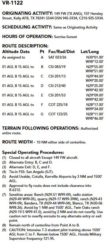
Did not know that - thanks! Right now in the 107 class I teach 4 numbered routes are lower (than 1500ft altogether), 3 numbered routes are higher (1+ segment higher than 1500ft).

Yep. You could bust out a sectional and show them the depiction of the route. Could also go the extra mile and download the DOD AP/1B and go over the specifics of the route as well. Probably not really worth it unless they’re near an MTR though.
 
Last edited:
I hate to see a fellow tactical aviator lose their life. If it wasn't him showing off it's a tragedy. If it was too much hot dogging, his lack of skill almost cost other people their lives and likely ruined a great low level forever. Either way, it's a crappy deal. Here's some pics of me in Star Wars a few months back after picking up a jet in California going to Red Flag.

Looks like it’s got a Warner Robins ALC mark on it. Seen a few of them come out of there stripped of paint for a post maint flight check before going back in service.
 
Yep. You could bust out a sectional and show them the depiction of the route. Could also go the extra mile and download the DOD AP/1B and go over the specifics of the route as well. Probably not really worth it unless they’re near an MTR though.
Hugely informative!

Could you decode the altitudes for this route?
01 AGL = 100ft / B? / 15 AGL = 1500ft
Terrain following operations?

MdwwUhr.png
 
Last edited:
Hugely informative!

Could you decode the altitudes for this route?
01 AGL = 100ft / B? / 15 AGL = 1500ft
Terrain following operations?

MdwwUhr.png

Correct. Add 2 zeros to the number to get the altitude.

The definition of terrain following probably varies by service. In the Army it is “terrain flight is a tactic that uses terrain, vegetation, and manmade objects to mask the aircraft from visual, optical, thermal, and electronic detection systems.”

Terrain flight:
Nap of the earth 0-25ft
Contour 25-80ft
Low level 80-200ft
 
Last edited:
As a 2Lt I remember a low level route we flew in Turkey that was inside a canyon and eye opening. Unfortunately some stupid flight lead decided to take our wing commander on a flight through it and that was the end of that.
 
The Navy for crashing the plane. The NPS for allowing them to be there. If they are closing the place down, that's an admission of negligence for allowing it to be there in the first place. POA for telling them all about how this place existed. It was here I first heard about it. I am emotionally hurt by this. I wanna piece of the action.

I saw an F18 take off from PT Mugu NAS once... I have been traumatized since... where is my check?
 
As I remember, there was a news story (like 60 minutes) about all the inexperienced weekend warriors on their hogs going out to "slay the dragon" and the amount of resources tied up in policing that area, the increased traffic, and frequent EMS callouts.

One law enforcement talking head, in so many words, declared war motorcycle "hooligans".
I saw part of it and turned that **** off. Typical hyped-up crap spewing from the narrator's stinkhole.
I'm gonna be there in a few weeks on a cruiser, taking it slow, enjoying the scenery, not racing "to the death", as the overly biased documentary would make you believe.
Then again, truth doesn't sell. Idiots love drama, hype and lies.
 
Possible GLOC makes sense.

 
Well, doesn’t look like mechanical, GLOC or “flat Hatting.”

 
Sure it's military, sure it's not all for public consumption, but this aircraft was no where near making it out of a place that many have gone before. I didn't read the report, just watched the video. He was 75 knots above the stated max of 525. Is there any reason that he would not have the voice or video recorders on? How do the military FDRs compare to a civilian one? Anyone know where the FDR is mounted on the aircraft?

Just seems a bit weird to me. Of course it just takes a second or two of distraction.

star-wars-canyon-crash.JPG star-wars-canyon-crash-map.JPG
 
Sure it's military, sure it's not all for public consumption, but this aircraft was no where near making it out of a place that many have gone before. I didn't read the report, just watched the video. He was 75 knots above the stated max of 525. Is there any reason that he would not have the voice or video recorders on? How do the military FDRs compare to a civilian one? Anyone know where the FDR is mounted on the aircraft?
Treading lightly and respectfully here...The video summarizes the report and describes it well. The route is regularly flown, but it is still possible to put yourself in a hole by being too low and or too fast - it speculates the possibility of being unable to turn inside the canyon walls and attempting to cross a ridgeline where the impact occurred. Listen again to the 'nose low and accelerating' part(s). It all comes down to timing and the report/video mention that the scenario resulted in CFIT in something like 30% of the post-mishap sim runs. Not a certainty but neither was survival.

As for cockpit video/audio, it's a tool for training and not required to be used at all times, and it's almost certain that any recording media in the vicinity of the cockpit was destroyed. The airplane has a deployable flight incident recorder mounted on the aft fuselage but the report says there was no data recovered, presumably due to the dynamics of the crash. It is not a traditional 'orange box' FDR but has enough to get the job done. It's also not likely that there was anything on it that would change the results, given the data that was available.

Nauga,
who has looked up at those ridgelines
 
He was 75 knots above the stated max of 525.

When CW said that near the end of the video, he misspoke. Earlier in the video, he clearly said the max speed on the accident flight was 550 kts, the 600 kts max occurred on the flight the day before.
 
Back
Top