Children of the Magenta Highlighter

iamtheari

Administrator
Management Council Member
Joined
Mar 15, 2016
Messages
4,509
Display Name

Display name:
Ari
I planned this flight at least 2 years ago, maybe 3. My home state, North Dakota, is one of those that has a "fly into all our airports and we'll give you a prize" states. There are 89 public airports in the passport book. Of those 89, 17 lack hard-surface runways. Of those 17, 13 of them are distant. I long ago decided to use the J-3 Cub to visit those 13 airports in one long trip. When this weekend came along and I had some free time, good weather statewide, and a dogsitter, I decided to jump in the plane and get it done.

My self-imposed rule was not to use anything for navigation that was not available when the plane was built in 1941. I planned it on sectionals and A/FDs using a plotter and an E-6B. I flew it using the sectionals and a mechanical watch. The compass in the Cub is pretty bad--the correction card is basically written as an apology to the pilot--but I did an informal compass swing a while back and noted down where it was pointing on various known headings to use along the way. Mostly, I relied on section lines (which are public easements under North Dakota law, so most of them in the flat country have gravel roads; the rest often have cattle fences or a change in farming practices between their owners) to orient myself to true headings.

In order to make sure nobody mistakenly thinks I'm actually a good pilot, I used a magenta highlighter on the sectional to give myself a comforting magenta line to follow all the way.

I left Saturday morning, wheels up at 9:30 a.m. by the time I baked some pita bread, stopped to buy some other provisions, loaded up the plane, and got fuel. I got home at 1:00 p.m. on Sunday. I logged 11.2 hours, used 60.9 gallons of avgas, flew 750 nm, and landed at 17 different airports (including my home airport and three fuel stops at airports with paved runways). I camped on an airport couch in a very nice building at one of the unpaved airports, rather than sleeping in a tent listening to mosquitoes all night. Southeastern North Dakota is a very damp place, great for mosquitoes.

The first day took me farther than halfway, easily enough to qualify for the commercial solo cross-country, had I not already accidentally done a few other flights that meet those requirements: at least 300 nm total distance (I did 478), landings at 3 points (I did 11), and one point of landing at least 250 nm from departure point (my farthest point from home was 270 nm away). I feel like this trip also met the spirit of the solo cross-country requirement, being done truly VFR.

No flight plan was filed. And I did not use flight following, because I don't have a transponder and my handheld radio mostly picks up the magneto noise anyhow. :)

Here are a few pictures I took along the way, in part to have documented proof that I actually landed at some of the sketchier airfields that I have heard of people driving to for the stamp rather than actually flying in.

Loaded and ready to taxi to the fuel pumps
AEJ00893.jpg

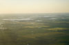
Leaving my home town behind me
AEJ00897.jpg

First landing: D49 Columbus, about 25 nm from the Canadian border
AEJ00900.jpg


Second landing: 5B4 Bowbells
AEJ00901.jpg

That's KMIB Minot Air Force Base in the background. I got to land there last summer. The site wouldn't let me upload the full-quality original of this picture, where you can just about make out the runway numbers. Due to lack of identifiable features on the ground for much of my trip, I had to invent VFR checkpoints like "line the right wing up with the air base and the only town northeast of it."
AEJ00910.jpg

Third landing: D61 Towner, at 78 nm, the longest leg other than the final one over familiar territory coming home
AEJ00912.jpg

An interesting farming practice southeast of Towner
AEJ00916.jpg

I stopped at 5H4 Harvey for fuel, but didn't take any pictures. The next passport stamp landing was D24 Fessenden
AEJ00918.jpg

I wasn't the only one enjoying the perfect weather, with a high in the 70s and almost no wind
AEJ00930.jpg

The next stop was 8M6 McVille. I made it around the R-5402 airspace without being intercepted. I didn't even check if it was active, because doing so would have violated my navigational technology rule. Navigating around it without a GPS was more sporting.
AEJ00931.jpg
 
The real reason I navigated the way I did: a 3-year payoff to post on Pilots of America about Children of the Magenta Highlighter
AEJ00932.jpg

Next stop: 1A2 Arthur
AEJ00938.jpg

Crossing I-94 with Fargo in the distance
AEJ00941.jpg

North Dakota's unofficial state tree is the utility pole. We really don't have a lot of trees. But we do have some.
AEJ00945.jpg

4N4 Lidgerwood, the roughest surface I have ever landed on. The runway was mowed so you could see the width of it okay, but it was a little nerve-wracking to bounce along the rough surface with water lapping at both runway edges.AEJ00946.jpg

Compared to the previous landing, 4R6 Milnor was a wonderfully smooth, well-marked runway. The airport manager came out to visit with me a while and invited me to their fly-in on August 25.
AEJ00949.jpg

AEJ00950.jpg

I stopped at KGWR Gwinner for fuel, again without taking any pictures. Here is the final approach for Day 1, with a wind farm just off the approach course to D03 Kulm. Their town festival is now called Kulm Windfest Days, because of this wind farm. The fly-in is the morning of August 17.
AEJ00951.jpg

My campsite, in the very nice terminal at D03 Kulm. The airport manager's brother drove out to see who had landed and gave me a tour of their very nice hangars, almost insisting that I use one and finally just giving me the code in case I changed my mind. They had a copy of 16 Right (which I have) and a copy of Living in the Age of Airplanes, which I watched and enjoyed but not nearly as much as 16 Right.
IMG_2322.jpg
 

Attachments

  • AEJ00951.jpg
    AEJ00951.jpg
    828.3 KB · Views: 28
Day 2 began with a short hop to 9G9 Gackle. This was one of the two airports in the state that I looked at on Google Earth and was not able to figure out where the airport was supposed to be. The A/FD entry changes each cycle to indicate that the water level has come up and the runways (they have 08-26 and 17-35, both turf in fair condition) have gotten shorter. There is actually a NOTAM now saying that 17-35 is longer than the A/FD shows, so they must have had a dry spell. I flew over and decided to land on 08. It was a non-event compared to how psyched up I had made myself about this one.
AEJ00952.jpg

6H8 Hazelton is clearly used almost exclusively by a spray operation. There were two fuel tanks, a couple of trailers, etc. that were all private, and then this little mailbox with the passport stamp in it.
AEJ00954.jpg

Approaching the Missouri River south of Bismarck. This is back to familiar territory for me. It was the second Missouri River crossing of this trip, but there were more to come.
AEJ00957.jpg

After my fuel stop at Y19 Mandan, where I was given a doughnut even though I was not Oshkosh-bound (the intended audience for the doughnuts), I headed north to pass over the refinery before turning northeast, which kept me out of the Class D airspace for Bismarck. Here is a shot of the state capitol and KBIS runway 13. Our state capitol is the tallest building in the state, a 17-story Art Deco office building that was built during the Great Depression after the previous capitol building burned down.
AEJ00966.jpg

Now I am back in the Devils Lake West MOA, for the second time on this trip. I landed at 7G2 McClusky, which is only 30 nm away from my first fuel stop at Harvey. But this is the way the round trip route worked out best. McClusky was the sketchiest runway of the trip. It had not been mowed and the runway edge marker cones were obscured by the weeds. This truck has permanent plates so I don't know when it was last registered, but I did see a can of baked beans inside the cab, with a handwritten date of 2015 on the lid.
AEJ00968.jpg

Here is a good view of one of the easier airports to identify, 91N Turtle Lake. Most of them were not this easy.
AEJ00972.jpg

At Turtle Lake
AEJ00973.jpg

Visible from Turtle Lake is the power plant near Washburn
AEJ00974.jpg

Here is one of the coal strip mines that feed the power plants
AEJ00976.jpg

Now I am headed west, past Lake Audubon
AEJ00977.jpg
 
What a great adventure and story. Great pictures too.

I tried finding this; What is the “prize” for filling the passport?
 
Here is a view of US-83 where it separates Lake Audubon (on the east, to the right) from Lake Sakakawea (on the west/left)
AEJ00979.jpg

This is Mallard Island, a place that I didn't know about until I flew over it once and did some research. (I don't feel bad, though. No other North Dakotan I have talked to has known about it before I brought it up, either.) It was separated from the mainland by the flooding of the reservoir behind Garrison Dam, which we know as Lake Sakakawea. The island itself is part of a state wildlife management area known as Wolf Creek WMA. The island is closed to motorized vehicles and aircraft.
AEJ00980.jpg

This seems to be an old homestead on Mallard Island, with the house gone and only this Quonset hut, small storage building, and a few miscellaneous structures standing now. It seems to me that the Quonset would have been pre-dam but the other things do look more modern. Equipment can get across on the ice during the winter, to tend to maintenance of the land on the island.
AEJ00987.jpg

The Garrison Dam is the fifth-largest earthen dam in the world. On the south side (background of this picture), parallel to the dam, is the 37N Garrison Dam / Riverdale airport, which is one of the few unpaved airports in the state that I did not land at on this trip. I had been there a few years back in the Cub and this trip was ambitious enough already.
AEJ00993.jpg

South of New Town, I diverted a bit out of my way to be upwind of this oil well fire.
AEJ01015.jpg

This little sandstone school house is a landmark of western North Dakota. I grew up near it and should know the history better than I do. For today's purposes, it just means that I was almost home.
AEJ01018.jpg
 
What a great adventure and story. Great pictures too.

I tried finding this; What is the “prize” for filling the passport?
https://aero.nd.gov/education-programs/passport-program/

There are 3 levels:

If you land at 30 airports and attend 1 FAA safety seminar, you get a polo shirt
If you land at 60 airports, visit 1 air museum (there are 2: Minot and Fargo), and attend 2 FAA safety seminars, you get a flight bag
If you land at all 89 airports, visit both air museums, and attend 3 FAA safety seminars, you get a leather jacket

I consider our jacket to be a discount compared to other states that have similar programs. For example, Minnesota does this but they have 133 airports.
 
I was unaware that magenta highlighters existed in 1941. Great trip, though!
Okay, you caught me cheating just a little. I just checked, and it turns out that the highlighter was not invented until 1963. But if I hadn't used a magenta highlighter, what would I have entitled this thread?!? :)
 
What witchcraft is this??!?

But seriously, looks like a ton of fun. I'm a little bit jeal-ly.
Far too many of my flying hours have been following a GPS. I really would recommend navigating the old-school way once in a while just for the breath of fresh air. I feel a lot better about myself knowing that I can navigate with a paper chart if my panel dies. Picking checkpoints on the chart and then identifying them from the air is a skill that we mostly just give a polite nod to in primary training, and then move on to the GPS and CDI for all our real navigation needs. I won't get on a soapbox about it, but I had a really good time planning and finally flying this trip because I put all my trust in myself rather than an electronic device.
 
You are purposely drawing a purple brontosaurus that's walking to the left; aren't you?

I KNEW IT!!!
I have to work on Tuesday, so I can't go to Oshkosh this year. If I can't go to Oshkosh, I'm gonna draw dinosaurs. (Sad fact: Using a pencil and paper, I actually can't draw a better dinosaur than you see on that chart.)
 
My hat's off to you sir! Sounds like a blast. And, this thread definitely didn't go where I thought it was going.

By the way, have you read "Flight of Passage" by Rinker Buck?
 
That was way too cool and I’m way too jealous.

I also didn’t know N Dak had so much water.

My family is from S Dak and it’s so much dryer.

Beautiful shots. And your memories will be even more vivid.

You learned a valuable lesson though. Always take the couch when it’s offered. ;-)

Done that more than once for weather abs even did it once as a student pilot returning from an XC when the weather went to crap between “here” and home... and the sun would set if I went around Mr. Thunderstorm.

And never regretted grabbing the FBO couch over whatever other plans I had, unless they were a rental car and a hotel. :)
 
Okay, you caught me cheating just a little. I just checked, and it turns out that the highlighter was not invented until 1963. But if I hadn't used a magenta highlighter, what would I have entitled this thread?!? :)

A pencil would have been more appropriate, even now, you can erase it easily when you are done. It's funny this is considered a novelty now, but you know what, I lived the vfr ded reckoning and I will take the computer generated magenta line every time. I still find myself comparing landmarks to the chart on the MFD even now though. Nice post.
 
Okay, you caught me cheating just a little. I just checked, and it turns out that the highlighter was not invented until 1963. But if I hadn't used a magenta highlighter, what would I have entitled this thread?!? :)
Children of the Magenta Colored Pencil?

What a wonderful writeup of a fun trip. I'm more than a little jealous. I've never flown a Cub, but it looks like a blast. And Nebraska doesn't have any similar program... apparently they did something years ago, but I think the state is a little too apathetic now. I need to get cracking, though. as a starter I plan to visit every "fighter on a stick" gate guardian in the state this summer. There aren't many, but it's a start.
I have found out about fighters on a stick that I didn't even know about, at some of the airports I've flown into for no other reason than to get a stamp in my book.

A pencil would have been more appropriate, even now, you can erase it easily when you are done. It's funny this is considered a novelty now, but you know what, I lived the vfr ded reckoning and I will take the computer generated magenta line every time. I still find myself comparing landmarks to the chart on the MFD even now though. Nice post.
I planned it all with a pencil, but in my experience erasing pencil marks on a sectional tends to erase the sectional, too. I reused the same sectionals I had from my student pilot days for this trip, so they still showed my solo cross country and my private pilot check ride cross country plan. I used the highlighter mostly to support my joke, but also to keep myself from accidentally turning when my path crossed an old flight plan.

That was way too cool and I’m way too jealous.

I also didn’t know N Dak had so much water.

My family is from S Dak and it’s so much dryer.

Beautiful shots. And your memories will be even more vivid.

You learned a valuable lesson though. Always take the couch when it’s offered. ;-)

Done that more than once for weather abs even did it once as a student pilot returning from an XC when the weather went to crap between “here” and home... and the sun would set if I went around Mr. Thunderstorm.

And never regretted grabbing the FBO couch over whatever other plans I had, unless they were a rental car and a hotel. :)
Here's a tip: Keep a blanket and a pillow in the plane. After flying an instrument approach and going missed at my home airport because it was late and all the airport lights had failed, I diverted to a nearby airport with working lights and crashed on the airport couch. It was nearly the most comfortable place I've ever slept, except that the building was freezing cold and the thermostat was behind a locked door so I shivered all night.

South Dakota is definitely the dryer of the two Dakotas. In North Dakota, it gets dry as you go west across the Missouri. I'm from the dry part, but we've had more moisture than usual this year so it's lush and green everywhere. This trip covered the entire gamut, from the edge of the Badlands where I live to the "prairie pothole" region of a million little sloughs full of water. I will never forget the first time I flew across that area in the springtime. It was my first "use a plane to do something useful" cross-country, and I came back in the afternoon. Every plowed field was hot and every pothole was cold, resulting in constant, moderate chop the entire way home.
 
I planned it all with a pencil, but in my experience erasing pencil marks on a sectional tends to erase the sectional, too. I reused the same sectionals I had from my student pilot days for this trip, so they still showed my solo cross country and my private pilot check ride cross country plan. I used the highlighter mostly to support my joke, but also to keep myself from accidentally turning when my path crossed an old flight plan.
Eighty years ago when my dad flew cubs and biplanes for a living, he folded his sectionals with a crease from departure to destination fields, then flew the crease.
 
Great post! Great adventure! "Makes my heart soar like an eagle!” (or a C 150)... I hope I get back behind the yoke again soon, and frankly, I'd like to do it just like you did. With a chart, a prayer wheel, and my trusty folding plotter.

Thanks for sharing...

Sent from my moto z4 using Tapatalk
 
The pita bread is conspicuously missing.
I ate it all before I could take a picture. Sometimes I wish I hadn’t perfected that recipe. It has an unfortunate effect on useful load.
 
I noticed you skipped the dam airport, but have you also been to 4E8, Y99 and Y71? I am still too scared to land the Mooney on grass, so I don't know when I'll get to collect all these airport lacking pavement.
 
I noticed you skipped the dam airport, but have you also been to 4E8, Y99 and Y71? I am still too scared to land the Mooney on grass, so I don't know when I'll get to collect all these airport lacking pavement.
Make friends with someone who has tundra tires. I did Y99 Plaza in the Champ on Friday. I happened to be nearby and decided to give it a shot. The surface isn’t bad but I didn’t find the stamp. That is the other airport that I couldn’t identify from Google Earth (as mentioned above for Gackle), but I drove by it in 2016 to see what it looked like from the ground. I had included Plaza in this flight plan until I crossed it off last week.

4E8 Richardton and Y71 Elgin are the last two grass strips I need to visit. It worked better to plan those as a separate flight, which I can do some evening after work.
I've heard 4E8 doubles as a runway/cow pasture and is really rough with scattered piles of poo.
 
As a kid raised in North Dakota who learned to fly there, and still has most of my family there, I thoroughly enjoyed these posts! Back in college I flew a C150 up to Bowbells, ND to visit a couple of fraternity brothers. Their dad had a beautiful Cub-yellow J3 Cub that he took me up in which was my first experience in those wonderful little flying machines. Thanks for sharing the adventure!

Loren
 
Red neck 206.....

79-206rh3e.jpg


Note the mud flaps.... and do not use them for a step.
 
I was thinking "Children of the Magenta Crayon."
I thought about that, too. Or “Children of the Red Grease Pencil”, but who’d use either one on a sectional?

Side note... I bought some magenta colored removable tape from Sporty’s when I was a student pilot. I learned the first time I used it not to mark your route in magenta or red. At least not if you have any chance of needing to see it at night using a red flashlight.
 
Back
Top