Banjo33
Line Up and Wait
Flew the family down to Pensacola yesterday mid-morning for lunch and a movie, but knew going down that we would be dealing with the summer pop up thunderstorms on the way home in the afternoon. Sure enough, came out of the theater around 1500 to a torrential down pour and cells everywhere. Headed back to the FBO to turn in the rental car and start assessing the weather.
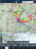
My route direct to home looked impassable due to large cells, so I was left with the decision to go east or west to work around them. Flight direct is only about 140 miles/1 hr. What you can’t see in the attached pic is the cell just north of P’cola that I was concerned would force me into the Eglin Restricted Areas to the east and the concern the line to the north would continue building east, so I elected to go northwest and try and work around it near Jackson.
Filing IFR was never considered as I like to keep the developing cells in sight visually as they can grow so quickly and it gets REALLY rough inside of even the small ones. Initially, there was a big hole in vicinity of Hattiesburg (the enroute point displayed in the pic), so that was the direction I was headed at 8500’. I chose higher to stay out of the scud and give me a better view of the CBs along the route. Sometimes lower works too as I can see the shafts of rain and avoid them (assuming very scattered storms); however, these cells were much larger and denser over the area I would be flying, so I knew navigating between them wouldn’t be an option I was comfortable with.
Abeam Mobile, Mobile approach advised me of a hole directly off my right wing that would provide a quick cut through and more direct flight home. However, visually, it was a wall of black in that direction. I have ADSB-in/out (GTX345) and the refresh rates were working well for me showing a magenta wall on the iPad in that direction. My storm scope also painted a wall of lighting in that direction. I just couldn’t see what he was seeing, so I elected to continue on course per my original plan. He actually sounded perplexed that I’d rather choose to go all the way to Jackson to get around the storms instead of direct. As I got closer to Hattiesburg, approach advised me that the R4401 was active and I’d need to remain clear. I also noted the cells were building real close to the NE corner of the R, so I adjusted course to the south.
To wrap this up, the cells were building rapidly and dissipating rapidly and the ADSB radar was keeping up well. There’s no way I would put full faith in it alone to keep my clear of the dangerous stuff in IMC in such a dynamic environment though. As part of the decision making process, it (and my storm scope) was a terrific situational awareness enhancer and let me keep my family updated of our progress along the route and for me to continue updating my plan (route, divert options, etc). ATC radar might have put me in a highly undesirable position too if I had gone with their recommendation. Eventually, at about where the NW edge of the 75 nm ring is, those storms burned out (turned to wide spread yellow/green) and I was able to cut across at 5500, and get home in nice weather. Of note, I hit a bug at 8500’ just after leveling off on departure that left a softball sized blotch of goop directly in front of my face. I never hit enough rain to wash it off. My normally 1.1 hr flight turned into 2 hrs; however, I flew about 3/4 of the route 20 kts slower due to the expectation of turbulence (never saw it, lol) from the storms.