Cross Country Weather iPad App?

Cogito

Pre-takeoff checklist
Joined
Mar 17, 2013
Messages
376
Location
Los Angeles
Display Name

Display name:
Cogito
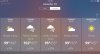
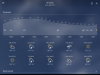
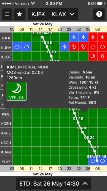
I’d been using The Weather Channel iPad app for planning flights between NY and LA. I’d load 10 cites across the country and swipe between them, looking at 10 day forecasts, and choose the best route and day(s) to fly.

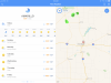
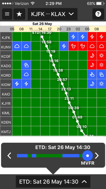
I also use ForeFlight Prog Charts and Winds Forecasts (and TAFs and MOS) when the possible day gets closer, but The Weather Channel app collated the information, gave a great overview.

The old Weather Channel app is no longer operational, replaced by one which doesn’t have the functionality described above. Does anyone know of a good iPad app for planning cross country flights?

Thanks for the help.
 
For official FAA weather the usual sources.

For seeing generally what’s going on along a route, Accuweather.
 
It's not free, or even cheap, but WeatherSpork does a great job of this.

Grid view will show the forecast at various points along your route at the time you're due to pass through, and allow you to move your ETD to find the best weather for the whole trip.

828588210646ffc0b7cf1707f1d7c7e0.jpg


c8ad1aea6c53c4eaf6bd8b5704d8c91d.jpg


There's a route view the shows a vertical profile of the weather and terrain along your route, and also allows you to change the ETD easily.

I generally like to use the free stuff that's available to use, but the one stop shopping aspect of this app makes it really excellent, and it has a host of information that isn't readily available.


Sent from my iPhone using Tapatalk
 
I second WeatherSpork.

It will not give you 10 days out, but it does do 3 days.

For longer term I suggest you run the model yourself.

http://mag.ncep.noaa.gov/model-guid...p=Model Guidance&model=GFS&area=NAMER&ps=area

It will give you a basic 7 day forecast for a specific location, though. You can't scroll through screens for different locations like you used to be able to do in the Weather.com app, but it's pretty quick to load a new location.


Sent from my iPhone using Tapatalk
 
I KNOW it's not exactly what you're looking for, but in garmin pilot if you enter a flight plan, you can scroll through a bunch of weather related stuff either using 'WX test" or the split screen widgets using the scroll bar at the bottom. this will show you info all along your route, metars, tafs, winds aloft etc... doesn't do long term forecasts (I guess you could change the dates of the flight) but it is easy to scroll thru and get the full picture. speaking of picture, here's a bunch...

Screenshot_20180525-085708.png
Screenshot_20180525-085730.png
Screenshot_20180525-085737.png
Screenshot_20180525-085746.png
Screenshot_20180525-085754.png
Screenshot_20180525-085808.png
 
Thanks for the replies so far. I’ve downloaded and tried a dozen or so. An app called “Weather’ Pro” from Impala studios is the closest I’ve found so far, though not as simple and clear as the defunct The Weather Channel App.

Thanks for suggesting Weather Spork, it’s an interesting display of data and I’d probably give it a try except $80. Per year. You did warn us about the price.

I’ll keep looking.
 
I’m 100% with the OP - when STORM went away today, my favored planning app did too. Its replacement STORM RADAR is no way comparable. I plan to tell them so in App Store review, suggest you do likewise.
 
Foreflight plus weather cams, in the lower 48 I haven't found a really comprehensive map overlay yet, wunderground used to be ok, but seems to have gone down hill.

It would ROCK if foreflight put a weather cam add on layer in their maps, show a little icon where a weather cam is, click it and see the cam, kinda like the FAAs weather cams up north

IMG_1894.jpg
 
Thanks for the replies so far. I’ve downloaded and tried a dozen or so. An app called “Weather’ Pro” from Impala studios is the closest I’ve found so far, though not as simple and clear as the defunct The Weather Channel App.

Thanks for suggesting Weather Spork, it’s an interesting display of data and I’d probably give it a try except $80. Per year. You did warn us about the price.

I’ll keep looking.
Your suggestion of WEATHER’ PRO is appreciated - actually quite similar to STORM. Thanks!
 
Thanks for the replies so far. I’ve downloaded and tried a dozen or so. An app called “Weather’ Pro” from Impala studios is the closest I’ve found so far, though not as simple and clear as the defunct The Weather Channel App.

Thanks for suggesting Weather Spork, it’s an interesting display of data and I’d probably give it a try except $80. Per year. You did warn us about the price.

I’ll keep looking.

FWIW, the guy behind weather spork participates in a couple of aviation forums and regularly offers free weather interpretation advice. He responded to a question of mine on Beechtalk. All the free advice he gives is worth something, so I decided to invest in him, at least for a year. The price also includes a lot of weather instruction through his online workshops. I think most of the pre-recorded stuff is free and you get discounts to webinars.

Not trying to give you the hard-sell, just sharing what I found.


Sent from my iPhone using Tapatalk
I’m glad you suggested Weather Spork and I hope the creator does well with it. I have trouble rationalizing paying more than what I pay for ForeFlight for an app that does far less. But if I worked for an airline and had to schedule flights every day, I would consider it. To be honest I dislike recurring payments if I can avoid them. I used to use LogTen Pro, Photoshop, After Effects, Premier, MS Word, etc. and have found other apps that work as well. I’m sure these app makers are doing just fine without my business.

I tried another dozen weather forecast apps today. Believe it or not Yahoo Weather seems to be the latest contender. I’ll bet they get their data from The Weather Channel, seems similar. Also, they have an option for wind speed in Knots.
 
Thanks for suggesting Weather Spork, it’s an interesting display of data and I’d probably give it a try except $80. Per year. You did warn us about the price.

I’ll keep looking.
For the $80, you getting more than just the weather forecast features.

You also get access to many of the education modules that @scottd has created. And there is lots and lots of good content there.
 
I love all the options for weather but the reality is the forecast models still don’t get it all right often enough to trust these things when the weather is iffy, and that’s when you really need it.

If you haven’t had a forecast that looked solid and tight go to complete crap, you just haven’t been flying long enough. :)
 
The reality is that there’s no forecast that claims to be perfect. However, there’s a lot of useful guidance you can extract out of those imperfect forecasts. The key is understanding how to do that consistently assuming you aren’t using anything from The Weather Channel. ;-)
I'm sure the weather channel is an approved source. The physical attributes are undeniable...
 
The old The Weather Channel iPad app, which alerted that it was no longer supported and which didn’t work at all on Thursday when I started this thread, appears to be operational today. Probably just a short stay of execution, but wanted you all to know not to delete the app just yet if you find it as useful as I do.

This gives a chance to compare with the new contenders for the Inexpensive Cross Country Weather Overview App title.
 

Attachments

  • 2E660961-F272-4285-8965-C4D7C5492250.jpeg
    2E660961-F272-4285-8965-C4D7C5492250.jpeg
    69.2 KB · Views: 25
  • AEB1EB5C-B758-4277-A640-0D3AD6136D73.jpeg
    AEB1EB5C-B758-4277-A640-0D3AD6136D73.jpeg
    67 KB · Views: 21
  • E3BF8F8A-550F-4D02-846A-D44FF1DA1B4F.png
    E3BF8F8A-550F-4D02-846A-D44FF1DA1B4F.png
    532.7 KB · Views: 21
  • F732454B-8E40-4997-8FE7-864071EAC54A.png
    F732454B-8E40-4997-8FE7-864071EAC54A.png
    917 KB · Views: 22
Your suggestion of WEATHER’ PRO is appreciated - actually quite similar to STORM. Thanks!
I downloaded it. It was only a few $. I like the layout but was surprised when I clicked on the play button for the radar loop. There is a subscription model to activate it.
I also don’t care for subscription model software. I much prefer to pay for the software upfront and be done with it. Those days are gone I guess.
 
Well, subscription-free apps are available and you'll likely need to put up with watered down features and ads (or selling your info without your knowledge) and you won't likely get 24/7 support and an organization that will continue to develop groundbreaking features that make it easier for you to plan a flight (not a picnic) with much more confidence.
I didn’t say free - I just don’t like the recurring subscription fees that seem to be the model most software is moving to. It may well work for the people that are flying for a living.

I have seen some of your videos Scott and like the content. If I ever start flying IFR with some regularity, I will gladly sign up.

This particular app I referenced above charged a small fee to buy the app. I was surprised when I clicked play on the radar loop and I also need a subscription. I am all for paying for content, It is just too easy to loose tract of all these recurring subscriptions. The same thing is happening with all the software I use at work. I don’t need upgrades every year, but we are getting them because we have to pay the subscription. My home copy of Office 2007 is more than powerful enough to meet my needs.

It got to the point where software developers weren’t making big enough improvements in the software to entice people to buy the newest version. With the subscription model they can have poor feature progression and still get your coin.

Just my 2c.
 
If I want to know whether I need to pack an umbrella or jacket for my trip, free is perfect. I believe there's a fair amount of value to pay for a service to know how the weather may impact my *flight* with easy to understand graphics and the best time to plan that return trip. You'll find WeatherSpork is going to provide a more mission-oriented product from that perspective. In our 7 day, you'll get relevant information to flying such as windspeed and direction. In the meteogram you'll see freezing level, winds aloft, crosswind information as well as ceilings and visibility. If I'm making decisions for the best opportunity to make a VFR flight, the WeatherSpork Grid view is outstanding. Personally, The Weather Channel graphics just don't provide the appropriate weather guidance from a pilot's perspective (or at least not mine).

I also doubt that if you reach out to The Weather Channel you'll get an aviation weather expert respond to your question or understand your suggestion. Even some of the other very popular aviation apps you may pay a subscription to, can't provide that level of service. Moreover, they tend to just throw weather data at you hoping you can figure it all out. That's not our plan for WeatherSpork.
I agree there is a place for paid aviation weather. For most of us it’s Garmin Pilot or ForeFlight which has this information and a whole lot more. Prog Charts, Winds Aloft, Icing, Ceiling, and Turbulence Forecasts, Radar, Satellite, Pireps, TAFs, TFRs Metars, Airmets, signets, etc. All laid over VFR or IFR Charts. It has a system to plot your flight path and then sync it wirelessly to the G3X Touch in your airplane. I’m not saying anything new, we’ve all used these apps.

I was perhaps unclear, but I’m looking for a light overview app to replace the one I’d gotten used to that appears to be discontinued. If you’re able to compete with the big app developers and find a business model that works for you, all the power to you.

There’s a gentleman who makes a fine logbook app called MyFlightBook which I found by asking a similar question on this forum. Ironically, I started the thread because I’d paid $75 for a logbook app that was advertised to be a full payment, not a subscription. This was a bait and switch and I commend you for not doing that. You’re upfront about the cost of your app and I wish you well.
 
If you’re a member of AOPA there is a new app (that is free) called AOPA GO that is great for weather. Can put in your flight plan route and it will show wx along the route. Can even file flight plan and get weather briefing. Check it out
 
Understood, that's why I said "subscription-free" apps in my post.


How does an app support itself on a single purchase when it has to pay for data/services on a recurring basis? For example, to get decent lightning data, it's not free. Unlike NEXRAD that is owned by the gov't, lightning data is owned by the companies that have the detection networks. If I were to pay $1500/mon for that data (that's an average cost), but only sell the app for $4.99, I'd have to get 3600 subscriptions each year to pay for that data alone. And that doesn't cover the customer service team, developers and cost of infrastructure, insurance, etc. And, oh, I'd like to be able to pay my bills.
Scott - that is an good explanation. I wasn’t aware that developers have to pay for some of the weather data. I suspect others did not know that either. We all like to pay our bills, that is why I like to understand what the charges are for. I am more willing to sign up for a subscription based app if I know their are recurring charges. Your explanation helps. Thank You
 
I just signed up through Avwxworkshops.com and downloaded the app. It is less than the cost of my usual flight around the loacal area. I’m looking forward to the education! - Thanks for your responses.
 
If you’re a member of AOPA there is a new app (that is free) called AOPA GO that is great for weather. Can put in your flight plan route and it will show wx along the route. Can even file flight plan and get weather briefing. Check it out

I did, terrible interface.

Weather is just metars,tafs of airports along your route.
No auto complete, no graphics, they might as well just give a command line. They give you categories like vor, airport, etc for you waypoints, but you still have to type it in?

I use Garmin pilot and fltplan go as my backup.
 
Perhaps I was unclear. Many of these other apps just throw a bunch of weather products (those that you mentioned) at you and force you to figure it all out. I tend to think this is very old school. Not that this information isn't valuable or useful, but it's how it's presented that makes it just painful to consume for many pilots...which can result in bad decisions. I've taught thousands of pilots about weather over the last 20 years and I really do understand the difficulty weather planning is for many pilots. Much of this stems from the point I just made. I am not trying to compete with the popular EFBs you may use in the cockpit...in fact, I see my product as a companion to those that adds value, saves time and is easy to use.
Pricing apps is difficult, no doubt about it. Generally it’s a decision between a price that makes the app maker feel good, just compensation for all the hard work he put into it, or making money. The ebook industry just went through this. After years of exponential growth, publishers decided they didn’t like a low perceived value of their properties. The prices went up and ebook sales fell.

Meanwhile, in the search for simple, inexpensive weather apps to supplement ForeFlight or Garmin Pilot: I’m flying back from NY to LA. Within 3 minutes of opening The Weather Channel app I see I’ll probably have to leave early tomorrow morning to get past Alberto. Now I’ll open ForeFlight and look at Prog Charts and Winds Forecasts and make a tentative flight plan. If TWC app stops working again I’ll use Yahoo Weather as a backup unless someone kindly posts a better option. I appreciate everyone’s help.
 
Looks like the old Weather Channel app (not the new one in the app store, which is an abomination,) that was working again for the last 19 months, has finally come to an end. Doesn't even open on the iPad. What free or reasonably priced weather apps have you been using to supplement ForeFlight or Garmin Pilot for real cross country (ie LA-NY) weather planning?
 
Last edited:
If you asked me, this sort of need is where graphical weather forecast maps shine. Helps to see the big picture, and you can better understand things... what happens if that front speeds up a bit? etc....
Drives me nits that surface analysis charts aren't so prevalent anymore. It used to be that every TV news weather spot had them, now not so much....
 
What free or reasonably priced weather apps have you been using to supplement ForeFlight or Garmin Pilot for real cross country (ie LA-NY) weather planning?

I star with MyRadar.
 
It was mentioned before. Windy. I start with cloud base graphics and then animate.

4ECA98FA-A132-4DA8-83A9-C83BFC337B0F.png
 
I love Weatherspork. There is so much great info presented in a clever and useful way. I do wish there were updates to the app - like the ability to organize Favorites, a way to quickly view or scroll through multiple airport METARS. TAFS etc on the Airport view page. It is my go to app for longer cross countries. I wish it were my go to app for quick glance at weather but it's a little slow and clunky for this. Still the best for complete weather though.
 
I love Weatherspork. There is so much great info presented in a clever and useful way. I do wish there were updates to the app - like the ability to organize Favorites, a way to quickly view or scroll through multiple airport METARS. TAFS etc on the Airport view page. It is my go to app for longer cross countries. I wish it were my go to app for quick glance at weather but it's a little slow and clunky for this. Still the best for complete weather though.
Does it still cost as much as ForeFlight?
 
Back
Top