The airport in my strawman only has a 700' class E transition area and not only a 200-3/4 LPV but two 200-1/2 ILS approaches. There's little between the final approach corse of these approaches and my field except some open space and Lake Norman.
You are using an out of date browser. It may not display this or other websites correctly.
You should upgrade or use an alternative browser.
You should upgrade or use an alternative browser.
IFR to fields with no approaches...
- Thread starter cowman
- Start date
aterpster
En-Route
- Joined
- Apr 15, 2011
- Messages
- 3,317
- Display Name
Display name:
aterpster
Hope they understand TERPs and RNAV avionics integrity and alerting issues.Yeah
Yup. I've heard rumors about local folk who have 'roll your own' Approaches.
flyingcheesehead
Touchdown! Greaser!
And I can think of one or two fields around here where, even though an IAP exists, the MDA is so high that you might be better off filing to a nearby Class D with an ILS or LPV, canceling, and proceeding VFR to the destination field.
Can you provide some examples? I'm curious to see how that would work, and maybe why they have such high mins. Thanks!
")
luvflyin
Touchdown! Greaser!
In practical terms you mean Class E Surface Area airports have at least one ILS. But, there are many airports now with LPV to 200-300 DAs that don't have a Class E Surface Area. FWIW.
Yeah. I knew there some, just didn't think it was 'many.'
luvflyin
Touchdown! Greaser!
Hope they understand TERPs and RNAV avionics integrity and alerting issues.
I don't think most understand the math and details of TERPS. But they understand the intent, which is dont hit the rocks and buildings and antennas and stuff. People were 'rollin' their own before GPS.
flyingcheesehead
Touchdown! Greaser!
Yeah. I knew there some, just didn't think it was 'many.'
It's many now... There aren't a ton of uncontrolled fields with surface E, I think those mainly exist at airports where there used to be an FSS, or where there was airline service at one time. Now, through the proliferation of GPS approaches with LPV mins, you can get down to 200-250 AGL at a lot of airports - I would guess probably the majority of paved IFR airports now.
aterpster
En-Route
- Joined
- Apr 15, 2011
- Messages
- 3,317
- Display Name
Display name:
aterpster
Lots of LPV, but the runway needs precision markings, a vertical survey, and a clear zone between DA and the runway. LP is the choice for runways that don't meet all those requirement. And, LPV minimums can't be less than 1 mile unless there is parallel taxiway,It's many now... There aren't a ton of uncontrolled fields with surface E, I think those mainly exist at airports where there used to be an FSS, or where there was airline service at one time. Now, through the proliferation of GPS approaches with LPV mins, you can get down to 200-250 AGL at a lot of airports - I would guess probably the majority of paved IFR airports now.
luvflyin
Touchdown! Greaser!
It's many now... There aren't a ton of uncontrolled fields with surface E, I think those mainly exist at airports where there used to be an FSS, or where there was airline service at one time. Now, through the proliferation of GPS approaches with LPV mins, you can get down to 200-250 AGL at a lot of airports - I would guess probably the majority of paved IFR airports now.
Yeah. Scanning around on the charts I'm seeing that. Found a few where there used to be a Tower also, closed Military fields. I expected to see more because I thought that some ASOS's met the weather reporting requirement.
aterpster
En-Route
- Joined
- Apr 15, 2011
- Messages
- 3,317
- Display Name
Display name:
aterpster
Often, airline service. Also, direct communications with FSS or ATC on runways. And, wx reporting, although all IFR airports have that now.It's many now... There aren't a ton of uncontrolled fields with surface E, I think those mainly exist at airports where there used to be an FSS, or where there was airline service at one time. Now, through the proliferation of GPS approaches with LPV mins, you can get down to 200-250 AGL at a lot of airports - I would guess probably the majority of paved IFR airports now.
Airports with RNP AR approaches get a surface area when the comm requirement can be met and there is either no tower or a part-time tower. This is because RNP AR approaches do not have circling minimums.
luvflyin
Touchdown! Greaser!
So this happened yesterday.
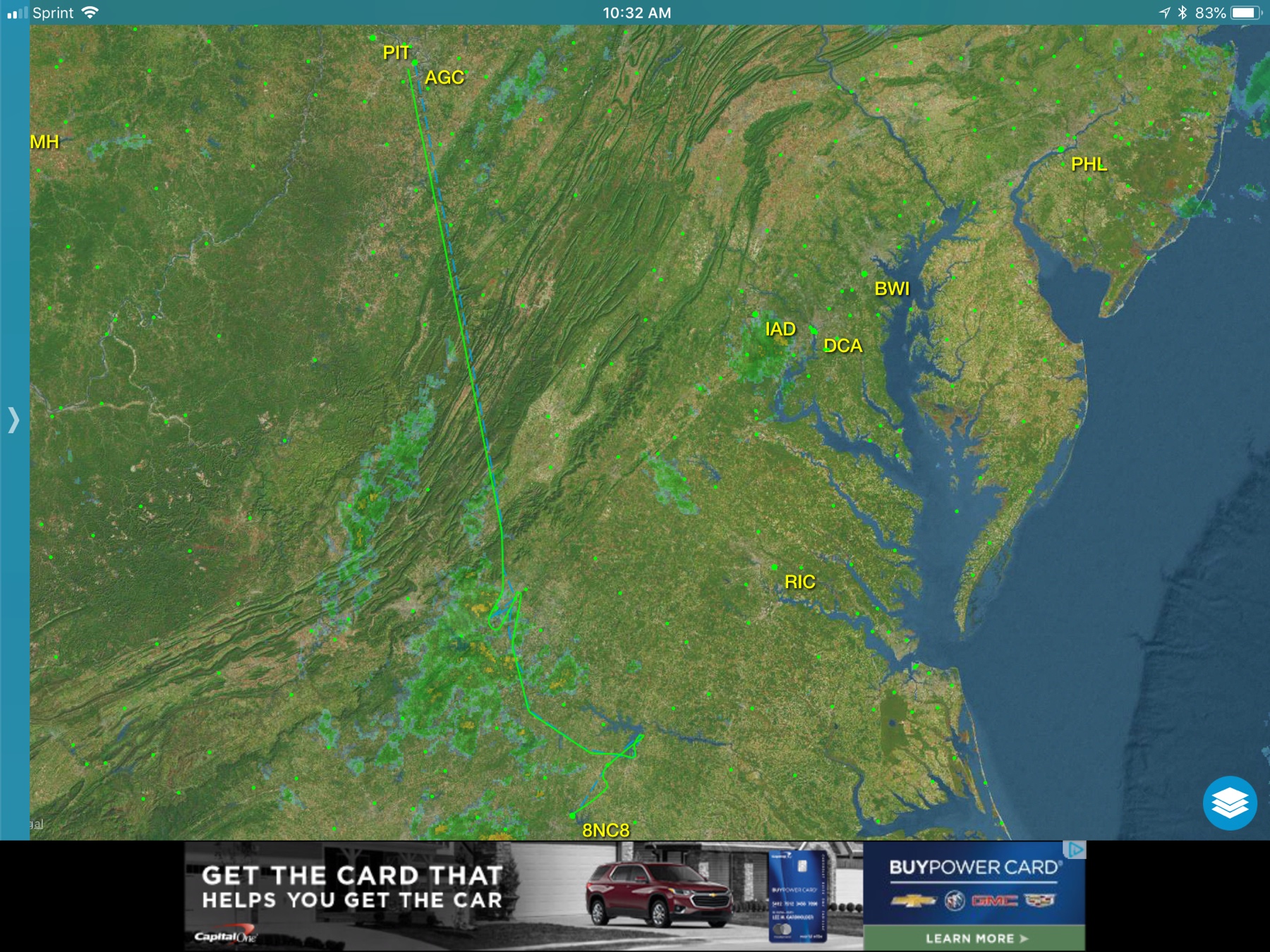
I filed KAGC KLYH KDAN KTDF 8NC8 with KRDU the alternate. The intent was do the last approach at KTDF and VFR underneath Home. Per my flight plan comments my intent was to fly missed approaches at 3 ‘ports and land at 8NC8. Good shot at some approaches in actual for proficiency and currency.
The early morning Wx agreed with shooting a nice low RNAV into KLYH. But KDAN had a small cell cluster growing nearby and KTDF was getting worse. So I requested RNAV 24 at KHNZ.
At this point the controller at KRDU had is hands full but was totally in control. He gave me a delaying vector and a ‘standby’ while he shaked and baked the stack. At one point I got a somewhat non-standard “descend 4,000, once there, clear direct VEKUC and the RNAV 24.” I descended then turned for VEKUC. I was handflying the whole way but when I hit execute on the electronics, it led me thru a procedure turn which benefited from a descending turn to 3k before intercepting the GS. Perfect slam dunk but to me a somewhat unusual clearance.... but it immediately got me going without more chatter.
I flew the procedure into my favorite ‘get home’ Airport. Why a favorite? My original CFII had demonstrated how one could ‘scud run’ home following I-85 from there. Even though his demo scared me a bit, since then I’ve flown between those 2 Airports more than 60 times when I was finishing my build. The interstate run had a cell sitting over it but there were 1,200’ ceilings just to the east and I had a very pleasant trip home over territory I had seen a lot of before.
That was a very engaging and satisfying flight. The most important decision was not trying that route the previous evening when conditions were worse. It was a nice hotel room.
Sent from my iPad using Tapatalk Pro
That's a great example. Thanks for taking the time to put it together and posting it. When it's in your own back yard and you've done it many times before in good weather it's not necessarily 'kinda unsafe' to do it in 'marginal' weather
luvflyin
Touchdown! Greaser!
Often, airline service. Also, direct communications with FSS or ATC on runways. And, wx reporting, although all IFR airports have that now.
Airports with RNP AR approaches get a surface area when the comm requirement can be met and there is either no tower or a part-time tower. This is because RNP AR approaches do not have circling minimums.
Yeah. That's why I was expecting to see a few more than I did.
flyingcheesehead
Touchdown! Greaser!
Lots of LPV, but the runway needs precision markings, a vertical survey, and a clear zone between DA and the runway. LP is the choice for runways that don't meet all those requirement. And, LPV minimums can't be less than 1 mile unless there is parallel taxiway,
Which of those requirements are met the least often?
I must admit, I haven't seen very many approaches at all that have LP minimums but not LPV. It seems like the ones that don't have LPV only have LNAV.
azure
Final Approach
Which is why I put "alternate" in quotation marks...I’ve found that while filing an alternate is both mandatory and a good preflight planning exercise, once in the air it means little. What I’ve actually thought about before and during the flight is going to drive the decision process. And to the extent that ATC is helpful in decision making based on current conditions (and at times I’ve found them extremely helpful) the only useless bit of information on the table is my filed alternate.
So I routinely file KRDU as my alternate simply because when flying direct to the obscure 8NC8, it seems to give faraway controllers some idea of where I’m headed, that is, my home port is next to KRDU. My actual alternate planning is a separate exercise and is subject to update as forecasts become actual.
Sent from my iPad using Tapatalk Pro
azure
Final Approach
The one that I was thinking of in particular was 2B3, where the MDA on the RNAV 36 is something like 1900, which is 1200 AGL. It's not uncommon to have low conditions to the south that would preclude getting in with that approach, but one might be able to shoot the ILS into KLEB and proceed visually to 2B3 if conditions to the north were higher. Granted, there is a ridge in the way that would require climbing to about 3000, which wouldn't work if ceilings were uniformly low, but that isn't always the case.Can you provide some examples? I'm curious to see how that would work, and maybe why they have such high mins. Thanks!
Not that I've actually had occasion to do this, but I've noticed a time or two when it would have been a possible way in.
Palmpilot
Touchdown! Greaser!
You don't get vectored. You start down an approach to somewhere else and hope you reach VFR weather and cancel.
I agree that you can do that. I'm just saying that a visual approach is also an option when the clouds are above the minimum vectoring altitude.
Fearless Tower
Touchdown! Greaser!
Kind of depends on your definition of ‘scud running’. Some people use it for anything MVFR while others use it to imply less than legal or borderline legal flying.If it’s far, scud running seems stupid in either case.
There is nothing inherently stupid about flying 1000-1500’ AGL below a 2500-3000’ overcast layer.
Palmpilot
Touchdown! Greaser!
That wasn’t about being vectored. It was about @flyingron ’s post #19 where he was doing an Approach and then cancelling when breaking out underneath
EDIT: note to self, don’t reply right away. Read a few more posts to see if it’s already been answered
I wasn't commenting on post #19. Here's the sequence of events:
Post #21:
It would also be beneficial to read AIM 5-4-23, which is the section on visual approaches. The weather at the airport has to be at least 1000 and 3, but you don't have to maintain VFR cloud clearance, just have the airport in sight and remain clear of clouds. ATC can authorize a visual approach to an airport that has no weather reporting "provided there is a reasonable assurance that weather at the airport is a ceiling at or above 1,000 feet and visibility 3 miles or greater (e.g., area weather reports, PIREPs, etc.)."
Post #22:
You can be legal VFR with other than 1000 and 3. 1000 means squat in uncontrolled airspace. Mile and clear of clouds is all you need. All I need is to breakout below 700'
Post #28:
You can breakout higher. You just can't cancel until below 700
Post #29:
The chart I looked at shows the floor of class E at 1200 AGL over M34.
https://skyvector.com/?ll=37.00511164045384,-88.35536956218426&chart=301&zoom=2&fpl=undefined
The problem is, how do you get vectored that low when the minimum vectoring altitude is almost 2000 AGL.
The only point I was trying to make is that a visual approach is an option when the clouds are above the minimum vectoring altitude. I'm not saying that it's necessarily better, just that it's another tool in the tool box.
aterpster
En-Route
- Joined
- Apr 15, 2011
- Messages
- 3,317
- Display Name
Display name:
aterpster
LP and LPV cannot coexist to a given runway. And, where LPV doesn't qualify, LP will be charted only if at least a 20' lower MDA can result over LNAV.Which of those requirements are met the least often?
I must admit, I haven't seen very many approaches at all that have LP minimums but not LPV. It seems like the ones that don't have LPV only have LNAV.
The requirement that is met least often is either the lack of a vertical survey or obstacles penetrating required clear areas between the proposed DA and the runway (vertical guidance surface). And, some airports don't want to pay for the required runway markings.
Last edited:
aterpster
En-Route
- Joined
- Apr 15, 2011
- Messages
- 3,317
- Display Name
Display name:
aterpster
flyingcheesehead
Touchdown! Greaser!
The one that I was thinking of in particular was 2B3, where the MDA on the RNAV 36 is something like 1900, which is 1200 AGL. It's not uncommon to have low conditions to the south that would preclude getting in with that approach, but one might be able to shoot the ILS into KLEB and proceed visually to 2B3 if conditions to the north were higher. Granted, there is a ridge in the way that would require climbing to about 3000, which wouldn't work if ceilings were uniformly low, but that isn't always the case.
Thanks! I like thinking through scenarios like this.
It looks to me like the main reason for the high minimums is that the approach into 2B3 is not parallel to the valley the airport is in. That ridge in between KLEB and 2B3 gives me pause, though... That's pretty high. I think I'd rather go around it! It looks like it'd be possible to follow the Connecticut River from KLEB down toward Claremont, or the road down toward Sunapee Lake and use the valley more to one's advantage. It looks like you'd still need pretty high ceilings to cancel and scud run legally from KLEB, though - 1500 AGL since there are some congested areas, so probably at least 2000 MSL if using the river route, higher for the road toward the lake. If the ceilings are uniform, that leaves you right back where you started.
I looked at another option, though: Flying the RNAV(GPS) 29 into KCNH. As soon as you hit the FAF you can drop to 1720 (180' below mins at 2B3), and past ZOBYY you can drop to 1520. If the clouds were below the 1900' mins at 2B3, you still couldn't cancel, but if you were able to look over your shoulder and see 2B3 I suppose it'd be legal to ask for a visual approach in there. Alternatively, if you know the terrain, you could probably request a contact approach to 2B3 once you break out, provided that happens high enough to maintain required minimum altitudes until the final descent.
As a local, what are your thoughts on those options?
luvflyin
Touchdown! Greaser!
While waiting for
While waiting for @azure ’s local knowledge I’d think Boston Center’s radio com coverage would figure in. Even if they had good coverage down low there I’d want to get it all coordinated with the controller before beginning the descent on the Approach to KCNH. They’d have to get your ‘2B3 in sight’ report before giving you the Visual Approach and having him ‘locked and loaded’ waiting to hear it and give you the clearance would be better than surprising him.
Thanks! I like thinking through scenarios like this.
It looks to me like the main reason for the high minimums is that the approach into 2B3 is not parallel to the valley the airport is in. That ridge in between KLEB and 2B3 gives me pause, though... That's pretty high. I think I'd rather go around it! It looks like it'd be possible to follow the Connecticut River from KLEB down toward Claremont, or the road down toward Sunapee Lake and use the valley more to one's advantage. It looks like you'd still need pretty high ceilings to cancel and scud run legally from KLEB, though - 1500 AGL since there are some congested areas, so probably at least 2000 MSL if using the river route, higher for the road toward the lake. If the ceilings are uniform, that leaves you right back where you started.
I looked at another option, though: Flying the RNAV(GPS) 29 into KCNH. As soon as you hit the FAF you can drop to 1720 (180' below mins at 2B3), and past ZOBYY you can drop to 1520. If the clouds were below the 1900' mins at 2B3, you still couldn't cancel, but if you were able to look over your shoulder and see 2B3 I suppose it'd be legal to ask for a visual approach in there. Alternatively, if you know the terrain, you could probably request a contact approach to 2B3 once you break out, provided that happens high enough to maintain required minimum altitudes until the final descent.
As a local, what are your thoughts on those options?
While waiting for @azure ’s local knowledge I’d think Boston Center’s radio com coverage would figure in. Even if they had good coverage down low there I’d want to get it all coordinated with the controller before beginning the descent on the Approach to KCNH. They’d have to get your ‘2B3 in sight’ report before giving you the Visual Approach and having him ‘locked and loaded’ waiting to hear it and give you the clearance would be better than surprising him.
flyingcheesehead
Touchdown! Greaser!
While waiting for @azure ’s local knowledge I’d think Boston Center’s radio com coverage would figure in. Even if they had good coverage down low there I’d want to get it all coordinated with the controller before beginning the descent on the Approach to KCNH. They’d have to get your ‘2B3 in sight’ report before giving you the Visual Approach and having him ‘locked and loaded’ waiting to hear it and give you the clearance would be better than surprising him.
Yes, definitely. I would put something in the remarks on the flight plan if I were thinking of doing something like that, and maybe give the last controller a reminder to look at said remarks.
John Collins
En-Route
I have flown an approach into 3G3 when ceilings were right at MVA, broken out, cancelled, and flown the two miles in MVFR to 15G. I always had the option in that case of landing at 3G3 or going missed!
That should work as long as you are able continue your approach and descend to 500 feet below the ceiling before you cancel IFR and are able to proceed under VFR.
John Collins
En-Route
I’ve found that while filing an alternate is both mandatory and a good preflight planning exercise, once in the air it means little. What I’ve actually thought about before and during the flight is going to drive the decision process. And to the extent that ATC is helpful in decision making based on current conditions (and at times I’ve found them extremely helpful) the only useless bit of information on the table is my filed alternate.
So I routinely file KRDU as my alternate simply because when flying direct to the obscure 8NC8, it seems to give faraway controllers some idea of where I’m headed, that is, my home port is next to KRDU. My actual alternate planning is a separate exercise and is subject to update as forecasts become actual.
Sent from my iPad using Tapatalk Pro
Controllers don't see alternates. Alternates are not included in the portion of the flightplan message sent to ATC for their use for an FAA/Domestic flightplan. They will see the remarks.
ChrisK
En-Route
Absolutely. It works well when ceilings are right at 3000' or not much lower. Pattern at 3G3 is 1800 and at 15G is 2000.That should work as long as you are able continue your approach and descend to 500 feet below the ceiling before you cancel IFR and are able to proceed under VFR.
At least the first 24 characters or so.They will see the remarks.
ChrisK
En-Route
During my IFR training I filed with an instructor and entered my desired practice approaches in the remarks section. After initial callup, the controller keyed up three times completely speechless. Eventually he said "did you put the approaches you want in the remarks?" Why yes, yes I did.At least the first 24 characters or so.
Not sure if the extreme confusion I caused was worth it, but it sure was fun.
Bill Watson
En-Route
Controllers don't see alternates. Alternates are not included in the portion of the flightplan message sent to ATC for their use for an FAA/Domestic flightplan. They will see the remarks.
Thanks for confirming what I sensed but did not know.
Sent from my iPhone using Tapatalk Pro
luvflyin
Touchdown! Greaser!
Controllers don't see alternates. Alternates are not included in the portion of the flightplan message sent to ATC for their use for an FAA/Domestic flightplan. They will see the remarks.
Yeah. They can get access to it pretty quick though. Only time it would matter would be a NORDO situation and there was reason to believe a divert to the alternate might happen
chemgeek
En-Route
- Joined
- Dec 5, 2009
- Messages
- 2,938
- Display Name
Display name:
chemgeek
No reason you can't file to a nearby airport with an approach, and if you can safely cancel and fly VFR to your home field, you are good to go. Before my home field had a good instrument approach (we have an LPV now that will get you to around 250 AGL), I would file to my home field, Syracuse as an alternate, and ask for a descent to the MVA directly over the field. If I could maintain VFR, I canceled and landed. If not, I made one run at the VOR approach. If that was no-go, thence to the ILS at Syracuse. Syracuse approach was perfectly happy to play this game and I could usually get home VFR more often than not.
And ATC would do what with such information.Yeah. They can get access to it pretty quick though. Only time it would matter would be a NORDO situation and there was reason to believe a divert to the alternate might happen
Either they are following the primary return and clearing the way or they have no clue what you're doing.
luvflyin
Touchdown! Greaser!
And ATC would do what with such information.
Either they are following the primary return and clearing the way or they have no clue what you're doing.
If there is Radar, that helps. There isn’t always. If unable to land at destination airport, knowing the Alternate is a pretty good clue to what the pilots anticipated actions are. “When an IFR aircraft experiences two-way radio
communications failure, air traffic control is based on anticipated pilot actions.”
Without RADAR they have no clue, flight plan information or not. The pilot may have ended up diverting in actual. They may try to get in (perhaps more than once) to their filed destination, they may decide to divert to some other more advantageous airport than the filed alternate. ATC pretty much has to block out the entire airspace from where the pilot was last known to be until they know what happened to him.“When an IFR aircraft experiences two-way radio
communications failure, air traffic control is based on anticipated pilot actions.”