Why is VOR painted red.

TheGolfPilot

Line Up and Wait
Joined
Jan 16, 2015
Messages
786
Location
Modesto, CA
Display Name

Display name:
Golfpilot
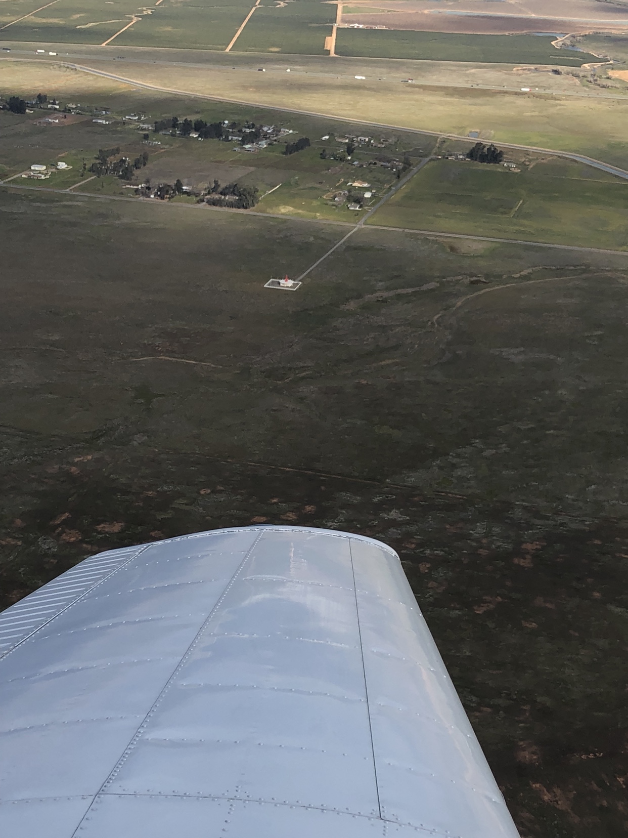
Saw this today. If I remember right it was the maxwell vor MXW. Anybody know why it is painted red. I also find it interesting that it appears on my ForeFlight WAC but not sectional. Now you see it, now you don’t kind of thing. Does red mean decommissioned?
a921a8a8e01e332e86f6d1c289c0ad90.jpg
 
Saw this today. If I remember right it was the maxwell vor MXW. Anybody know why it is painted red. I also find it interesting that it appears on my ForeFlight WAC but not sectional. Now you see it, now you don’t kind of thing. Does red mean decommissioned?
a921a8a8e01e332e86f6d1c289c0ad90.jpg

MXW appears to be decomissioned. It appears on no current Charts. The only current US WAC left is CJ-27, Puerto Rico and it expires March 29. Bye Bye WACs. Why it's red I don't now.
 
Because someone loved the old poem that included the phrase "noodle on a poodle"?
 
Even red nuns have odd green cans. Keep that thing on your right when returning to your home field.
 
VOR gnomes. I'm tellin ya. Ask your CFI about them. Ask your airport buddies about the gnomes that live in VOR's. they'll tell ya.
 
Sad. Soon there will be nothing left except GPS, and the old compass.
GPS the government can turn off any time they like. I'll bet there are very few pilots that actually fly using nothing but a compass.

I think I will do a new version of ADF that uses modern, lightweight electronics and both the AM and FM bands as a source.
It's not really that hard to do.
Then I can navigate and listen to the oldies station at the same time.
 
Sad. Soon there will be nothing left except GPS, and the old compass.

The FAA has promised that they won't get rid of all VOR's. They said they'd keep something called "Minimum Operating Network", whatever that means.
 
I think I will do a new version of ADF that uses modern, lightweight electronics and both the AM and FM bands as a source.
It's not really that hard to do.
Sell it in a kit form and you will make MILLIONS (well, perhaps Iranian Rials not U.S. Dollars, but millions none the less).
 
Because when they looked in the storage all they had was red paint..??
 
Local flight school uses it for Turns About A Point, being it's decommissioned. True. :popcorn:

Better then my horrible idea on doing turns around a deer stand outside of deer season. The poachers didn't much care for us circling them while they loaded two bucks into a pickup.
 
Better then my horrible idea on doing turns around a deer stand outside of deer season. The poachers didn't much care for us circling them while they loaded two bucks into a pickup.

Surprised they shoot at you!
 
Sad. Soon there will be nothing left except GPS, and the old compass.
GPS the government can turn off any time they like.
To be fair, they can do the same with VOR.

I like your new ADF idea. I'd work with you on that. Use a database of known AM & FM broadcast transmitters -- readily available information -- and determine your position by triangulation.
 
This sounds like a great idea however, I don't believe that the FAA will accept it as a form of IFR navigation because they don't transmit their identifier often enough.
 
This sounds like a great idea however, I don't believe that the FAA will accept it as a form of IFR navigation because they don't transmit their identifier often enough.
The HD data stream might be useful for that. That said, I wouldn't even want to think about any sort of FAA approval... ever.
 
This sounds like a great idea however, I don't believe that the FAA will accept it as a form of IFR navigation because they don't transmit their identifier often enough.
Include TV frequencies and tune to an infomercial channel.
 
Doing a "Stratux" type device using Software Defined Radio it should be possible to create an RNAV box that can determine where it is using the remaining VORs, AM/FM/TV/Cellular/ADS-B/Radar transmitters, etc. Add in the capability to not only use the US GPS system but the ones other countries are launching too and you'd have the ability to find your way in almost any conditions. Edit: oh, yea, can't forget ATIS/AWOS transmissions too.

If only there were some sort of high power long range navigational signal that the government could transmit from various places around the country.
 
Next Gen people. Next Gen!

All problems are solved! You can get the kids to Disney 5 minutes faster! That bald spot will fill in with hair and your teeth will be 4 shades whiter!

Come on! Have some faith! Next Gen! The future is NOW!
 
Doing a "Stratux" type device using Software Defined Radio it should be possible to create an RNAV box that can determine where it is using the remaining VORs, AM/FM/TV/Cellular/ADS-B/Radar transmitters, etc. Add in the capability to not only use the US GPS system but the ones other countries are launching too and you'd have the ability to find your way in almost any conditions. Edit: oh, yea, can't forget ATIS/AWOS transmissions too.

If only there were some sort of high power long range navigational signal that the government could transmit from various places around the country.

Old enough to remember LORAN?
 
Sad. Soon there will be nothing left except GPS, and the old compass.
GPS the government can turn off any time they like. I'll bet there are very few pilots that actually fly using nothing but a compass.

I think I will do a new version of ADF that uses modern, lightweight electronics and both the AM and FM bands as a source.
It's not really that hard to do.
Then I can navigate and listen to the oldies station at the same time.
Bring back the low-frequency radio range (LFR),
 
Doing a "Stratux" type device using Software Defined Radio it should be possible to create an RNAV box that can determine where it is using the remaining VORs, AM/FM/TV/Cellular/ADS-B/Radar transmitters, etc. Add in the capability to not only use the US GPS system but the ones other countries are launching too and you'd have the ability to find your way in almost any conditions. Edit: oh, yea, can't forget ATIS/AWOS transmissions too.

If only there were some sort of high power long range navigational signal that the government could transmit from various places around the country.

You’d need multiple good quality SDRs to do that. The cheap stuff doesn’t have the selectivity nor the switching speed to jump around that much.

Additionally many of those services can be switched to a backup transmitter at another location whenever the main fails. Without a way for your SDR box to know that happened, you’re in a world of crap. That’s why we tune AND identify Navaids. They don’t move but they do go out of service from time to time.
Just about anywhere in the US the position solution will be overdetermined to say the least. It might not be trivial to eliminate the invalid direction cuts but it shouldn't be too difficult.
 
Just about anywhere in the US the position solution will be overdetermined to say the least. It might not be trivial to eliminate the invalid direction cuts but it shouldn't be too difficult.

True. The reality is though to certify a multi-SDR RNAV radio like that would put its price tag as high as a Garmin. Game over.
 
True. The reality is though to certify a multi-SDR RNAV radio like that would put its price tag as high as a Garmin. Game over.
Can you imagine the cert standard? It works most of the time, really! And when it doesn't work nobody will know until it's too late. Oh well.
 
True. The reality is though to certify a multi-SDR RNAV radio like that would put its price tag as high as a Garmin. Game over.

That's why I was thinking more along the lines of a last resort kind of box like the AHRS in an ADS-B receiver.

For actual navigation it looks like the FAA is leaning towards DME/DME. Which of course requires an active transmitter and a whole bunch of money. But take that and mix it with a VOR crosscheck and you should have something certifiable that could sell for a price just slightly less than a new Cirrus.

I don’t think that’s leaning. That’s just recognizing there are a crap ton of airliners that use that still to keep the INS aware of where it is/calibrate it.

If we spend the money, GA avionics are way ahead of a lot of commercial aircraft that will be flying for a long time still.
 
Back
Top