Pixelated ADS-B radar?

cowman

Final Approach
Joined
Aug 12, 2012
Messages
5,280
Location
Danger Zone
Display Name

Display name:
Cowman
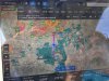
Is it my imagination or is it normally not this blocky? Also bonus question, how do you read this radar image?

IMG_4778.PNG IMG_4779.PNG
 
That's usually what I see on ADSB. At home on wifi or over cellular it's not as bad.

Looks like pop up storms to me, which means don't turn off your phone/iPad if it's a first generation so you can see how they are moving when you put it in motion.
 
That's about what I've been seeing, the new looping function is great and actually saved my butt last week. I assumed this storm was headed north east, like they normally do, and was going to hug the gulf coastline to get around it. But then I played the loop and it was headed south west which would have pushed me further out into the gulf than I was prepared for.IMG_0356.PNG
 
Here's a pic I took heading down to the eclipse where you can see the pixelated storms. You can also see the crazy amount of planes heading south.
 

Attachments

  • IMG_4065.JPG
    IMG_4065.JPG
    283.9 KB · Views: 75
Ok, so it's not just me... also answer to what the returns were: isolated pop-up showers and(theoretically) t-storms that were dissipating. Actual reality on the ground was apparently some light drizzle here and there.

I had seen it building around my destination point and decided to get going expecting that it would dissipate towards the end of the day but wanting to stay in daylight so I could see anything dangerous in my path. I'd already arranged for a friend to come get us at an alternate airport just in case but it did work out. I was kind of frustrated to see the blockiness while trying to asses the situation ahead though.
 
Hence the reason I have not yet switched off my XM subscription...
 
I like the picture from the xm weather ,much better.
 
Yeah, that's normal resolution. For my purposes (VFR only), the resolution is sufficient as I need to be well clear of the purple, red and yellow pixels. Given the potential time lag of an doppler radar image, the pixels provide what I consider reasonable temporal resolution as well as spatial resolution as the storm can move quite a bit between the time of the first and last bit of data collection and analysis within a particular volume of space (4-8 minutes between updates). I feel the pixel size is a good representation of the "smear" due to the data collection, analysis, and presentation time while a storm is moving. The XM (and ground-based) images I see do look a lot nicer but I'm not convinced they have more accurate, useful, data, especially when imaging a fast-moving storm system. Each of those pixels look to be about a square nautical mile in area and I'd probably would want to be at least 20 pixels away from any thunderstorm for my type of flying.
 
Weather via ADS-B is medium resolution
Yep, I recently had a chance to ask this question in an EFB product forum because it showed weather far more pixelated than what I was used to. Some apps massage the information to smooth it out to make it more visually appealing (and I think easier to read); others don't (or at least not as much).
 
Weather via ADS-B is medium resolution

Both XM and ADS-B Regional NEXRAD have similar pixel sizes, the XM rounds the edges. XM also indicates if the precipitation is frozen or not. The ADS-B CONUS NEXRAD product is 5 by 5 times the size of the Regional product.
 
Both XM and ADS-B Regional NEXRAD have similar pixel sizes, the XM rounds the edges. XM also indicates if the precipitation is frozen or not. The ADS-B CONUS NEXRAD product is 5 by 5 times the size of the Regional product.
This is a good point along with pointing out the tower system that may limit the data received at any particular time, e.g. you may have conus data and not have regional data.
 
I use Avare on a Android phone with the Flightbox/Stratux for ADSB in. Can see metars and traffic fine but the radar does not show up--does anyone with a similar setup get radar, or is this just a limitation of Avare?
 
Back
Top