You are using an out of date browser. It may not display this or other websites correctly.
You should upgrade or use an alternative browser.
You should upgrade or use an alternative browser.
182 Crash in Los Angeles
- Thread starter thebruce
- Start date
MAKG1
Touchdown! Greaser!
- Joined
- Jun 19, 2012
- Messages
- 13,411
- Location
- California central coast
- Display Name
Display name:
MAKG
4000 feet into Altadena? Accidental IMC? Those mountains are MUCH higher than that.
txflyer
En-Route
- Joined
- May 3, 2013
- Messages
- 4,509
- Location
- Wild Blue Yonder
- Display Name
Display name:
Fly it like you STOL it ♦
RIP. CFIT?
Cajun_Flyer
Pattern Altitude
A friend of mine was in the search and rescue ops for this. Said the clouds were really low and it was foggy all morning. The guy was way off course and not in contact with ATC. Very sad.
Pilawt
Final Approach
- Joined
- Sep 19, 2005
- Messages
- 9,478
- Display Name
Display name:
Pilawt
This photo, taken at 5,000' MSL, looks almost exactly in the direction of his path, according to Flightaware. He went a little to the left of that flat ridge with the white dot (observatory) -- that's Mt. Wilson, 6,179' MSL. The peaks beyond are 7,000'-8,000'.

thebruce
Pre-takeoff checklist
Just saw the local news coverage of it, which showed a photo taken of the ground search efforts. Visibility was zero on the mountain.Said the clouds were really low and it was foggy all morning.
luvflyin
Touchdown! Greaser!
RIP. CFIT?
It looks like CFIT based on the flight track log and a pic of the wreckage. Still at 4000 where it had been for about 15 minutes and the wreckage looked like high speed impact.
SoonerAviator
Final Approach
- Joined
- Jul 21, 2014
- Messages
- 9,337
- Location
- Broken Arrow, OK
- Display Name
Display name:
SoonerAviator
A friend of mine was in the search and rescue ops for this. Said the clouds were really low and it was foggy all morning. The guy was way off course and not in contact with ATC. Very sad.
How do they know he was "off course" if they weren't in contact with him (altitude notwithstanding)?
Cajun_Flyer
Pattern Altitude
How do they know he was "off course" if they weren't in contact with him (altitude notwithstanding)?
My understanding is he was initially in radar contact and filed his flight plan from San Diego to Santa Monica. Looks like he veered northeast close to the destination.

luvflyin
Touchdown! Greaser!
My understanding is he was initially in radar contact and filed his flight plan from San Diego to Santa Monica. Looks like he veered northeast close to the destination.
View attachment 45434
The turn northeast is routine there for vectors to the VOR A approach to SMO.
SoonerAviator
Final Approach
- Joined
- Jul 21, 2014
- Messages
- 9,337
- Location
- Broken Arrow, OK
- Display Name
Display name:
SoonerAviator
My understanding is he was initially in radar contact and filed his flight plan from San Diego to Santa Monica. Looks like he veered northeast close to the destination.
That makes sense. I thought we were talking about a VFR guy not in contact at all scud running.
MAKG1
Touchdown! Greaser!
- Joined
- Jun 19, 2012
- Messages
- 13,411
- Location
- California central coast
- Display Name
Display name:
MAKG
Apparently he was on an IFR flight plan in lost comms. Whether he knew comms were lost or not is not clear. That's awfully far to go for a vector without a turn inbound. I complain when I haven't been given a new vector and I'm leaving the approach area, or if I'm about to pass the final approach course. In the case of this particular approach, I'm not passing VNY R-095 without positive confirmation from ATC. The terrain is depicted on the plate, and it's not friendly.That makes sense. I thought we were talking about a VFR guy not in contact at all scud running.
RotorDude
Pattern Altitude
- Joined
- Aug 31, 2014
- Messages
- 2,321
- Display Name
Display name:
GliderDude
I recall an accident years ago, I believe not far from that same area (perhaps towards San Diego?), where a female IFR pilot (in IMC) was given a vector by ATC and then lost comms and flew into the side of a mountain. This case was often discussed during instrument training and I believe resulted in some procedural change in ATC vectoring into high terrain, which I don't recall. Anyone knows the details?
luvflyin
Touchdown! Greaser!
I recall an accident years ago, I believe not far from that same area (perhaps towards San Diego?), where a female IFR pilot (in IMC) was given a vector by ATC and then lost comms and flew into the side of a mountain. This case was often discussed during instrument training and I believe resulted in some procedural change in ATC vectoring into high terrain, which I don't recall. Anyone knows the details?
There was one in 1987. I think it had just departed VNY. Was on a northeasterly course. Not sure if it was a vector to, or a vector to join and resume V186. It took the airplane over BUR, where the Radar antennae is. Radar has a "cone of silence" just like VOR's. There is a sector boundary there and the airplane was being handed off. When it flew over the antenna the target was lost for a minute which is routine. But because it was in handoff status it didn't reaquire as it should have. It was a glitch in the ARTS III that was in use then. Controller lost the "pic." Pilot lost the pic to, that pic being "where am I, where and how high are the rocks."
RotorDude
Pattern Altitude
- Joined
- Aug 31, 2014
- Messages
- 2,321
- Display Name
Display name:
GliderDude
There was one in 1987. I think it had just departed VNY. Was on a northeasterly course. Not sure if it was a vector to, or a vector to join and resume V186. It took the airplane over BUR, where the Radar antennae is. Radar has a "cone of silence" just like VOR's. There is a sector boundary there and the airplane was being handed off. When it flew over the antenna the target was lost for a minute which is routine. But because it was in handoff status it didn't reaquire as it should have. It was a glitch in the ARTS III that was in use then. Controller lost the "pic." Pilot lost the pic to, that pic being "where am I, where and how high are the rocks."
There have been quite a few crashes into terrain due to confusion or misunderstandings, e.g. this one in 2004, where the pilot and ATC messed up a digit in the call sign.
But the one I am still looking for happened long before that, perhaps late 70's or early 80's, when the IFR/IMC pilot was given a vector into terrain and then lost comms (perhaps due to a loose headset connector or incorrect squelch setting?), and obediently followed that vector right into the mountain.
I always think of that case when I get a vector in IMC, and consider my modern GPS-based terrain warnings a critical no-go item for IMC flight.
I think with on-board traffic and terrain we should be much more immune today to ATC-related errors, and there are low-cost solutions available to achieve that redundancy.
(BTW, I am not saying this accident is ATC related in any way.)

Flying Viking
Pre-takeoff checklist
According to ABC / 10 News, it was a Plus One aircraft. ******nit.
thebruce
Pre-takeoff checklist
They showed a photo of the airplane on the news. I can't pull it up at the moment.it was a Plus One aircraft
malibugrif
Filing Flight Plan
- Joined
- Oct 7, 2009
- Messages
- 5
- Display Name
Display name:
malibu
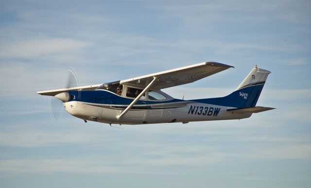
This hurts to see the picture above. It's me in the left seat flying out of Wikenburg, AZ in 2008 with a brand new paint job on 3BW. I was a partner in that plane for many years and flew her throughout California and Mexico. I loved her strength, speed and how she always got us home safely.
When I sold my share, 3BW was an amazingly well equipped airplane having an STEC 55X autopilot, a GNS530W and an Aspen 1000. My understanding is that the new partners put in an all new interior and provided the pilots a Stratus for even greater flight awareness. It truly breaks my heart to see it go down this way... I always thought that 3BW would soldier on.
My thoughts are with the pilot's family.
luvflyin
Touchdown! Greaser!
There have been quite a few crashes into terrain due to confusion or misunderstandings, e.g. this one in 2004, where the pilot and ATC messed up a digit in the call sign.
But the one I am still looking for happened long before that, perhaps late 70's or early 80's, when the IFR/IMC pilot was given a vector into terrain and then lost comms (perhaps due to a loose headset connector or incorrect squelch setting?), and obediently followed that vector right into the mountain.
I always think of that case when I get a vector in IMC, and consider my modern GPS-based terrain warnings a critical no-go item for IMC flight.
I think with on-board traffic and terrain we should be much more immune today to ATC-related errors, and there are low-cost solutions available to achieve that redundancy.
(BTW, I am not saying this accident is ATC related in any way.)
Time will tell.
jkaduk
Cleared for Takeoff
- Joined
- Feb 23, 2005
- Messages
- 1,289
- Location
- San Diego, California
- Display Name
Display name:
John Kaduk
Hard to understand how you can fly into a mountain with all the situational awareness tools that airplane had. I had time in it before the upgrade.
Flying Viking
Pre-takeoff checklist
Hard to understand how you can fly into a mountain with all the situational awareness tools that airplane had. I had time in it before the upgrade.
If there was a comm failure, it's possible that one or more of those tools had also failed. Or it could have been a medical emergency/loss of consciousness, and the AP keeping the plane on course. In any event it's pointless to speculate before the NTSB has done their thing.
RotorDude
Pattern Altitude
- Joined
- Aug 31, 2014
- Messages
- 2,321
- Display Name
Display name:
GliderDude
Time will tell.
I finally found that seminal accident by a female CFI crashing into a mountain while on ATC vector in IMC after going NORDO (Van Nuys to Santa Monica). It turns out Flying Magazine (Peter Garrison) had an "Aftermath" article about it. The NTSB record for it seems a bit sparse, however, so much of the data must be offline (it's from 1978).
Pilawt
Final Approach
- Joined
- Sep 19, 2005
- Messages
- 9,478
- Display Name
Display name:
Pilawt
If (and that's a big 'if') the Flightaware data is accurate, his groundspeed never wavered from around 145-150 knots, from the time he started the descent from 5,000 to 4,000 about 5 nm southeast of SLI, until the end of the track. My tendency would have been to slow it down that close to the destination, and especially while being vectored away from the destination and toward higher terrain.
RotorDude
Pattern Altitude
- Joined
- Aug 31, 2014
- Messages
- 2,321
- Display Name
Display name:
GliderDude
Not sure about the circumstances here, but I wonder if reading that above mentioned Flying article would have helped this poor dude.If (and that's a big 'if') the Flightaware data is accurate, his groundspeed never wavered from around 145-150 knots, from the time he started the descent from 5,000 to 4,000 about 5 nm southeast of SLI, until the end of the track. My tendency would have been to slow it down that close to the destination, and especially while being vectored away from the destination and toward higher terrain.
It has sure had a significant impact on my own IFR flying, as I think of that pilot every time I get a vector in IMC near terrain.
Last edited:
StinkBug
Cleared for Takeoff
Hard to understand how you can fly into a mountain with all the situational awareness tools that airplane had. I had time in it before the upgrade.
Complete electrical failure would explain lost comms as well as losing all the terrain avoidance aids. It seems unlikely, but so do most of the other explanations. At this point all we know is something went wrong with either the pilot or the airplane or both while in IMC near terrain.
MAKG1
Touchdown! Greaser!
- Joined
- Jun 19, 2012
- Messages
- 13,411
- Location
- California central coast
- Display Name
Display name:
MAKG
Flying in a straight line? I doubt it. Ground tracks look like hell for disoriented pilots.Spatial disorientation always a possibility too.
mscard88
Touchdown! Greaser!
Flying in a straight line? I doubt it. Ground tracks look like hell for disoriented pilots.
True perhaps, but still could have contributed to not interpreting his nav gear and other goodies he may have had in the plane. Unlikely as you say though.
Fearless Tower
Touchdown! Greaser!
3BW was indeed a very nice airplane. I think you guys painted it/redid the panel shortly after I joined the club. Very sad all around.This hurts to see the picture above. It's me in the left seat flying out of Wikenburg, AZ in 2008 with a brand new paint job on 3BW. I was a partner in that plane for many years and flew her throughout California and Mexico. I loved her strength, speed and how she always got us home safely.
When I sold my share, 3BW was an amazingly well equipped airplane having an STEC 55X autopilot, a GNS530W and an Aspen 1000. My understanding is that the new partners put in an all new interior and provided the pilots a Stratus for even greater flight awareness. It truly breaks my heart to see it go down this way... I always thought that 3BW would soldier on.
My thoughts are with the pilot's family.
The last 12 moths have been pretty tough for the club.
Glenn D
Pre-takeoff checklist
I friend of mine was on the Search and Rescue team.... he said it was 4000' and complete fog at the crash site.. not good.. hope we all learn from this and fly safer..
jkaduk
Cleared for Takeoff
- Joined
- Feb 23, 2005
- Messages
- 1,289
- Location
- San Diego, California
- Display Name
Display name:
John Kaduk
He had to have known that the tops weren't too far above. If I had all the screens go blank I'd dial in 7600 and get out of the soup pronto.Complete electrical failure would explain lost comms as well as losing all the terrain avoidance aids. It seems unlikely, but so do most of the other explanations. At this point all we know is something went wrong with either the pilot or the airplane or both while in IMC near terrain.
jkaduk
Cleared for Takeoff
- Joined
- Feb 23, 2005
- Messages
- 1,289
- Location
- San Diego, California
- Display Name
Display name:
John Kaduk
The last 12 moths have been pretty tough for the club.
No kidding.
luvflyin
Touchdown! Greaser!
He had to have known that the tops weren't too far above. If I had all the screens go blank I'd dial in 7600 and get out of the soup pronto.
Thats a good point. I'm not at all saying what was quoted above happened. Many things might have happened, many of which may have been beyond the pilots control. Giving yourself some "lost com" instructions is a good idea any time you get a vector toward "cumulogranite." "If I don't get turned in ___more minutes, I'm going to................
luvflyin
Touchdown! Greaser!
3BW was indeed a very nice airplane. I think you guys painted it/redid the panel shortly after I joined the club. Very sad all around.
The last 12 moths have been pretty tough for the club.
There was the Citabria a few weeks ago. What else?
There was the Citabria a few weeks ago. What else?
Mid-air at KSDM.
luvflyin
Touchdown! Greaser!
Mid-air at KSDM.
Oh. that was in the last year.