luvflyin
Touchdown! Greaser!
Did I get a prize for knowing one?")
You have to get it yourself. Get a box of Cracker Jack and let us know whatya got
Did I get a prize for knowing one?
as @luvflyin pointed out (and the AIM, as @dtuuri linked), the protected area isn't for the center of the runway or the runway complex. Instead, "Circling approach protected areas are defined by the tangential connection of arcs drawn from each runway end."Technical question, one when I looked never found a definitive answer; or am I over analyzing? (over analyzing is the more likely)
Circling is defined as X distance from the runway. Now, I have never know a runway for fixed wing airplanes to be a single spot; but instead a long line. So a Cat A is 1.3 miles. With a 5K runway, isn't the shape of the protected area more of an ellipse than a circle? Or is this implied? Think about landing at a large airport with circle to land; the ellipse long side could be longer than the width! How many pilots are really ready for that situation?
Tim

A fro dee anne slip?Great Typo. “Protested area.” Was it really a typo or are you going to take credit for it.
Nah...it’s because the Flight Check guys are pros, and they’re the ones that tested it...so it’s protested.A fro dee anne slip?
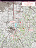
This is the actual TERPs for FWS, using the "new" circle to land criteria. These areas are identical for all three IAPs. The reason the CTL MDAs are higher on the ILS is because they cannot be lower than the LOC-only MDA:
My abysmal typing skill takes all the credit. I fixed it.Great Typo. “Protested area.” Was it really a typo or are you going to take credit for it.
That's something a cross-dresser wears.A fro dee anne slip?
I thought cross-dressers were the ladies who changed out the paraments at Easter time.That's something a cross-dresser wears.
Hoe does the shape of the protected area affect that?
Most of them have more varied wardrobes than many women. But, we digress about de dress.That's something a cross-dresser wears.
I guess of all the spatial difficulties I’ve seen pilots have with CTL, I’ve never seen invisible boundaries factor into it.When flying the circle portion, you are visual. As such, you judge the distance from the runway. First, note most pilots fly closer to a mile abeam the runway and then judge distance either based on well known landmarks or relative size of the runway compared to other objects within vision. If the runway is twice as large, you will be over twice the distance to have the same appearance. In which case, that can put you at two miles from the runway if you normally fly a one mile off beam downwind. Something I have seen when flying with other pilots multiple times.
The result, circle to land at a new airport (especially with reduced visibility) when IMC below TPA; for me is not quite an emergency landing, but I dam well have a better reason to tempt fate than gettheritis.
Note: my opinion will likely change when we can get a HUD with either the correct flight path or the distance information on it.
Tim
I found that in the IFP Gateway. The file date was 04/21/2020. This was there along with it also. It sure looks like the new stuff. The location of the Sycamore Strip Airport bears this out.
https://www.faa.gov/aero_docs/acifp/F38CF805357B4F6B8847954DC0E014ED-FWS/TX_KFWS_RNAV GPS RWY 35L_A1A_F.pdf
You don't know the people I knowI thought cross-dressers were the ladies who changed out the paraments at Easter time.
I assumed those were the new areas. You're right, of course.The published procedure used the old areas, which is the chart my comment was directed at.
The NOTAM updates any MDAs to reflect what the new areas would require - in this case Cats C and D go up. But this is a temporary NOTAM until (at some unknown time in the future) it is included in a published chart.
I assumed those were the new areas. You're right, of course.
What I don't understand is how they can issue the larger areas by NOTAM without a supporting TERPs map that documents the new obstacle clearance areas. I presume that obstacle assessment had to have been made.
That looks like the old areas.
Looks like the approach plates haven’t been updated, though.No, that's definitely the new areas. Radii of about 1.3, 1.8, 2.8, 3.7 nm. The old ones, Cat A/B/C were really close together at 1.3, 1.5, 1.7 then Cat D at 2.3.
Looks like the approach plates haven’t been updated, though.
Thanks! For sure, you know.No, that's definitely the new areas. Radii of about 1.3, 1.8, 2.8, 3.7 nm. The old ones, Cat A/B/C were really close together at 1.3, 1.5, 1.7 then Cat D at 2.3.
Why were't the three NOTAMs issued as abbreviated amendments, which would trigger charting?Correct. The approach plates themselves were designed with the old criteria. There is no "inverse C" next to the circling minima row.
The NOTAM was sent about a month ago. It was evaluated using the new criteria. The plate itself will presumably be updated at some point in the future. For now, there is the NOTAM, which provides the MDAs based on the new areas.
And the question seems to remain: Why is the CTL opposite the traffic pattern for all approaches to KFWS?
However (and perhaps to show the Chief Counsel does reconsider things from time to time), the FAA caught its own error and corrected it in the Collins letter. ATC, by definition, has no authority over Class G airspace.
What if the chart reads “Circling NA” where the “correct” pattern lies? Consider the RNAV(GPS) RWY 12 approach into Tracy, California (KTCY). The Chart Supplement tells us left traffic for all runways, but the approach chart notes tell us “Circling NA southwest of Rwy 12-30.” If inbound from the west with northwesterly winds, one might well choose to circle to 30. Does the prohibition against circling in the direction of the VFR traffic pattern equal authorization “by the approach guidelines of a specific airport” to circle against it?
The FAA hasn’t answered that yet and it’s always risky to speculate about regulations. One might think you should be able to—if you can’t circle one direction you should be able to in the other.
Office of the Chief Counsel:
On June 30, 2009, your office issued an opinion to a Daniel Murphy regarding the direction of allowable turns when circling to land at an uncontrolled airport. The following is quoted from the opinion:
Your letter requested clarification of the requirements in section 9l.126(b)(1) using the following example. A pilot, flying an aircraft under instrument flight rules in IMC, executes a circling approach to an uncontrolled airport. The airport, by operation of section 91.126(b)( 1), has established turns to the left for the approach. However, the pilot determines that turns to the left are undesirable because they are not in the interest of safety (for example, the wing of the aircraft blocks the view of the runway during turns to the left). You ask whether that pilot can make turns to the right on the approach. Section 91.126(a) states, in relevant part, that each person operating an aircraft on or in the vicinity of an airport in Class G airspace area must comply With the requirements of section 91.126 "unless otherwise authorized or required."
Section 91. 126(b)(1) states, in relevant part, that when approaching to land at an airport without an operating control tower in Class G airspace, "[ e]ach pilot of an airplane must make all turns of that airplane to the left unless the airport displays approved light signals or visual markings indicating that turns should be made to the right, in which case the pilot must make all turns to the right."
The use of "must" in sections 91.126(b)(l) and 91.126(a) do not permit a pilot's discretion in determining which direction to make turns when approaching the airport. Section 91.126( a) provides an exception to the requirement to make turns to the left if authorized or required by air traffic control (ATC). This exception permits a pilot to request clearance to make right hand turns under these circumstances. However, the regulation does not obligate ATC to grant such a request.
The current regulation reads (emphasis is mine):
Sec. 91.126 Operating on or in the vicinity of an airport in Class G airspace.
(a) General. Unless otherwise authorized or required, each person operating an aircraft on or in the vicinity of an airport in a Class G airspace area must comply with the requirements of this section.
(b) Direction of turns. When approaching to land at an airport without an operating control tower in Class G airspace--
(1) Each pilot of an airplane must make all turns of that airplane to the left unless the airport displays approved light signals or visual markings indicating that turns should be made to the right, in which case the pilot must make all turns to the right; and
(2) Each pilot of a helicopter or a powered parachute must avoid the flow of fixed-wing aircraft.
(c) Flap settings. Except when necessary for training or certification, the pilot in command of a civil turbojet-powered aircraft must use, as a final flap setting, the minimum certificated landing flap setting set forth in the approved performance information in the Airplane Flight Manual for the applicable conditions. However, each pilot in command has the final authority and responsibility for the safe operation of the pilot's airplane, and may use a different flap setting for that airplane if the pilot determines that it is necessary in the interest of safety.
(d) Communications with control towers. Unless otherwise authorized or required by ATC, no person may operate an aircraft to, from, through, or on an airport having an operational control tower unless two-way radio communications are maintained between that aircraft and the control tower. Communications must be established prior to 4 nautical miles from the airport, up to and including 2,500 feet AGL. However, if the aircraft radio fails in flight, the pilot in command may operate that aircraft and land if weather conditions are at or above basic VFR weather minimums, visual contact with the tower is maintained, and a clearance to land is received. If the aircraft radio fails while in flight under IFR, the pilot must comply with Sec. 91.185.
The regulation was not paraphrased accurately in the last paragraph of the above quoted opinion. The words “by air traffic control (ATC)” referred to in the opinion do not appear in 91.126(a). Instead, the exact wording is “Unless otherwise authorized or required,”. I believe this is intended and not an omission. 91.126(b) only applies to the case where there is not an operating control tower. Without an operating control tower, ATC does not exercise any authority in class G airspace. In this environment, one is not in communication with a tower. In fact, FAA Order 7110.65U, the following instructions to controllers are provided (emphasis is mine):
4−8−6. CIRCLING APPROACH
a. Circling approach instructions may only be given for aircraft landing at airports with operational control towers.
b. Include in the approach clearance instructions to circle to the runway in use if landing will be made on a runway other than that aligned with the direction of instrument approach. When the direction of the circling maneuver in relation to the airport/runway is required, state the direction (eight cardinal compass points) and specify a left or right base/downwind leg as appropriate.
Edit note: This letter continues in my next post because it is too large to fit in one post
As best I can tell from the FAA historical documents, Section 91.126 is an outgrowth of the earlier regulation 91.89. When part 91 was renumbered in 1989, 91.89 was restructured to be incorporated into 91.127 and 91-129. Originally, 91.127 dealt with non towered operation and 91.129 dealt with towered operation. The relevant wording in these two regulations in 1989 was:
§ 91.127 Operating on or In the vicinity of an airport: General rules.
(a) Unless otherwise required by part 93 of this chapter, each person operating an aircraft on or in the vicinity of an airport shall comply with the requirements of this section and, if applicable, of § 91.129.
(b) Each person operating an aircraft to or from an airport without an operating control tower shall--
(1) In the case of an airplane approaching to land, make all turns of that airplane to the left unless the airport displays approved light signals or visual markings indicating that turns should be made to the right, in which case the pilot shall make all turns to the right;
§91.129 Operation at airports with operating control towers.
[…]
(e)Approaches. When approaching to land at an airport with an operating control tower, each pilot of –
(1) An airplane shall circle the airport to the left;
Later 91.126 was added to the regulations when the airspace reclassification was enacted in 1991 to separate class E and class G airspace. Two notable changes occurred at the same time:
1) 91.126 added the phrase “Unless otherwise authorized or required” to section (a).
2) 91.129 (e) was re-sequenced to (f) and the phrase “Except when conducting a circling approach under Part 97 of this chapter or unless otherwise required by ATC” was added.
I believe that both changes were made dealing with similar issues in that they both anticipated that there were exceptions as a result of differing situations and conflicting regulations and as a result the direction of turn could not be absolute.
In 1994, 91.126 was modified again to clarify the difference between operating in a towered and non towered environment within class G. Sub paragraph (b) was clarified to apply to non towered operation and a new section (d) was added to cover towered communications when they were applicable.
Sec. 91.126 Operating on or in the vicinity of an airport in Class G airspace.
(a) General. Unless otherwise authorized or required, each person operating an aircraft on or in the vicinity of an airport in a Class G airspace area must comply with the requirements of this section.
(b) Direction of turns. When approaching to land at an airport without an operating control tower in Class G airspace--
[…]
(d) Communications with control towers. Unless otherwise authorized or required by ATC, no person may operate an aircraft to, from, through, or on an airport having an operational control tower unless two-way radio communications are maintained between that aircraft and the control tower.
[…]
This email is continued in the next post.
There are several distinctions when operating in class G airspace, first, in the vast majority of situations, the aircraft is not likely to be in contact with ATC and ATC does not exercise control in class G airspace unless there is an operating control tower. Second, if the conditions permit circling, they would also permit operation of VFR aircraft in that airspace, as circling minimums are never lower than 1 mile and clear of clouds, which is the VFR minimum. Therefore, a pilot must always consider the possibility of VFR traffic when circling in class G airspace and should make all turn compatible with the established traffic pattern. If the circling minimums are inside class E airspace above class G airspace, then the requirements for VFR flight at the circling altitude may preclude VFR traffic from operating at circling altitude in that airspace, at least from a legal standpoint. It still makes sense in most cases to follow the established traffic pattern. Note that the pattern altitude and direction is subject to the local authority and may be established because of noise, terrain, or other factors. In the case of circling requirements, they are established according to TERPS and ATC criteria. On a straight in approach, the circling minimums may never be lower than the lowest MDA for a given straight in approach. Sometimes this puts the circling altitude above pattern altitude and in other cases it can be substantially below pattern altitude. It is the exception when the pattern altitude and circling altitude are the same. There are cases where circling is prohibited by part 97, yet the airport uses a standard pattern. An example of this occurs at KBLF Bluefield WV RNAV (GPS) RWY 5 approach in which circling is prohibited east of runway 5/23 yet there are no “approved light signals or visual markings indicating that turns should be made to the right”. (note: the airspace at KBLF is class E except during the hours stated in the AFD, when it reverts to class G airspace).Thus, circling to runway 23 must be to the right, but the pattern direction is to the left. I presume this situation is permitted by the text “unless authorized or required”.
However, other regulations come into play which may require a different direction of turn to circle to land other than part 97. 91.175 specifies that when circling to land, one must maintain the minimum flight visibility and clear of clouds. An example would be low hanging clouds on the side of the airport that prevent circling to the left.
The use of the term “required” is normally included with a modifier to specify what is required when the regulator wants to specify a specific regulation or authority. In this case, it does not make practical sense to assume it means “if ATC requires” or any other specific modifier as the regulator has no problem using a modifier in other regulations or even this specific terminology when it is intended to refer to ATC as it is later in paragraph 91.126 (d), 91.127 and 91.129. The term is also used in 91.3, but here it refers to situational circumstances and not to a specific regulation “91.3 (b) In an in-flight emergency requiring immediate action, the pilot in command may deviate from any rule of this part to the extent required to meet that emergency”. This reference to 91.3 is simply to provide an example where the use of the modifier to the word “required” is clearly situational. By not restricting the wording of “required” with a modifier, it is apparent that the regulator anticipated circumstances that might be both regulatory and or situational. In other words, if the regulator wanted to restrict the meaning to just regulation conflicts, they could have said “required by regulations of this part” or referenced to any specific regulation as is common in the wording of numerous other regulations.
The FAA provides pilots with information in the form of AC’s, the AIM and other publications. Although they are not regulatory, according to the AIM, it states:
Flight Information Publication Policy d. This publication, while not regulatory, provides information which reflects examples of operating techniques and procedures which may be requirements in other federal publications or regulations. It is made available solely to assist pilots in executing their responsibilities required by other publications.
The AIM discussion offers the following (emphasis is mine):
5−4−20. Approach and Landing Minimums f. Circling Minimums. In some busy terminal areas, ATC may not allow circling and circling minimums will not be published. Published circling minimums provide obstacle clearance when pilots remain within the appropriate area of protection. Pilots should remain at or above the circling altitude until the aircraft is continuously in a position from which a descent to a landing on the intended runway can be made at a normal rate of descent using normal maneuvers. Circling may require maneuvers at low
altitude, at low airspeed, and in marginal weather conditions. Pilots must use sound judgment, have an in depth knowledge of their capabilities, and fully understand the aircraft performance to determine the exact circling maneuver since weather, unique airport design, and the aircraft position, altitude, and airspeed must all be considered. The following basic rules apply:
1. Maneuver the shortest path to the base or downwind leg, as appropriate, considering existing weather conditions. There is no restriction from passing over the airport or other runways.
2. It should be recognized that circling maneuvers may be made while VFR or other flying is in progress at the airport. Standard left turns or specific instruction from the controller for maneuvering must be considered when circling to land.
3. At airports without a control tower, it may be desirable to fly over the airport to observe wind and turn indicators and other traffic which may be on the runway or flying in the vicinity of the airport.
REFERENCE− AC 90−66A, Recommended Standards Traffic patterns for Aeronautical Operations at Airports without Operating Control Towers.
4. The missed approach point (MAP) varies depending upon the approach flown. For vertically guided approaches, the MAP is at the decision altitude/decision height. Non−vertically guided and circling procedures share the same MAP and the pilot determines this MAP by timing from the final approach fix, by a fix, a NAVAID, or a waypoint. Circling from a GLS, an ILS without a localizer line of minima or an RNAV (GPS) approach without an LNAV line of minima is prohibited.
Here is what is written in the Instrument Flying Handbook -2012 just published by the FAA:
Turning the shortest direction is not always going to be compatible with left turns.
In “The FAA Instrument Flying Handbook – 2012”, it states (figure 10 is attached to this email):
Figure 10-13 shows patterns that can be used for circling approaches. Pattern A can be flown when the final approach course intersects the runway centerline at less than a 90° angle, and the runway is in sight early enough to establish a base leg. If the runway becomes visible too late to fly pattern A, circle as shown in B. Fly pattern C if it is desirable to land opposite the direction of the final approach, and the runway is sighted in time for a turn to downwind leg. If the runway is sighted too late for a turn to downwind, fly pattern “D.” Regardless of the pattern flown, the pilot must maneuver the aircraft to remain within the designated circling area. Refer to section A (“Terms and Landing Minima Data”) in the front of each TPP for a description of circling approach categories. The criteria for determining the pattern to be flown are based on personal flying capabilities and knowledge of the performance characteristics of the aircraft. In each instance, the pilot must consider all factors: airport design, ceiling and visibility, wind direction and velocity, final approach course alignment, distance from the final approach fix to the runway, and ATC instructions.
Figure A and figure D shown do not necessarily comply with a strict rule to fly the pattern to the left. In another section of the AIM, it notes that if the alignment with a runway is more than 30 degrees, a straight in approach procedure will not be published and only circling minimums are available. In this situation, turning the shortest distance to align with the runway will not always be compatible with the pattern direction.
It should be abundantly clear that the writers of the AIM and the FAA Instrument Flying Handbook indicate that the pilot must take the direction of circling of potential VFR traffic into consideration but that this is not an absolute mandate as indicated by your referenced interpretation.
I would appreciate it if you would review this decision and coordinate with the appropriate organizations within the FAA as in some cases as currently written, it may lead to an accident and does not currently comport with most pilot’s understanding including the writers of the AIM and the Instrument Flying Handbook as evidenced by their text.
Regards,
John D. Collins
this is the continuation of the email:
Also the turf runway is not to be used during IFR or nighttime conditions, per the DCS: Rwy 17L–35R avbl only during dalgt/VFR and dry weather surface conditions.And the question seems to remain: Why is the CTL opposite the traffic pattern for all approaches to KFWS?