Paper sectional charts- are we still using them?

Do you still fly with paper charts?

  • Yes, I use paper charts as my primary source

    Votes: 14 8.3%
  • Yes, I keep current paper charts as a backup

    Votes: 43 25.4%
  • Yes, I have paper charts for backup but they're not current

    Votes: 49 29.0%
  • No, I'm fine with electronic options only

    Votes: 60 35.5%
  • Who needs a map?

    Votes: 3 1.8%

  • Total voters
    169
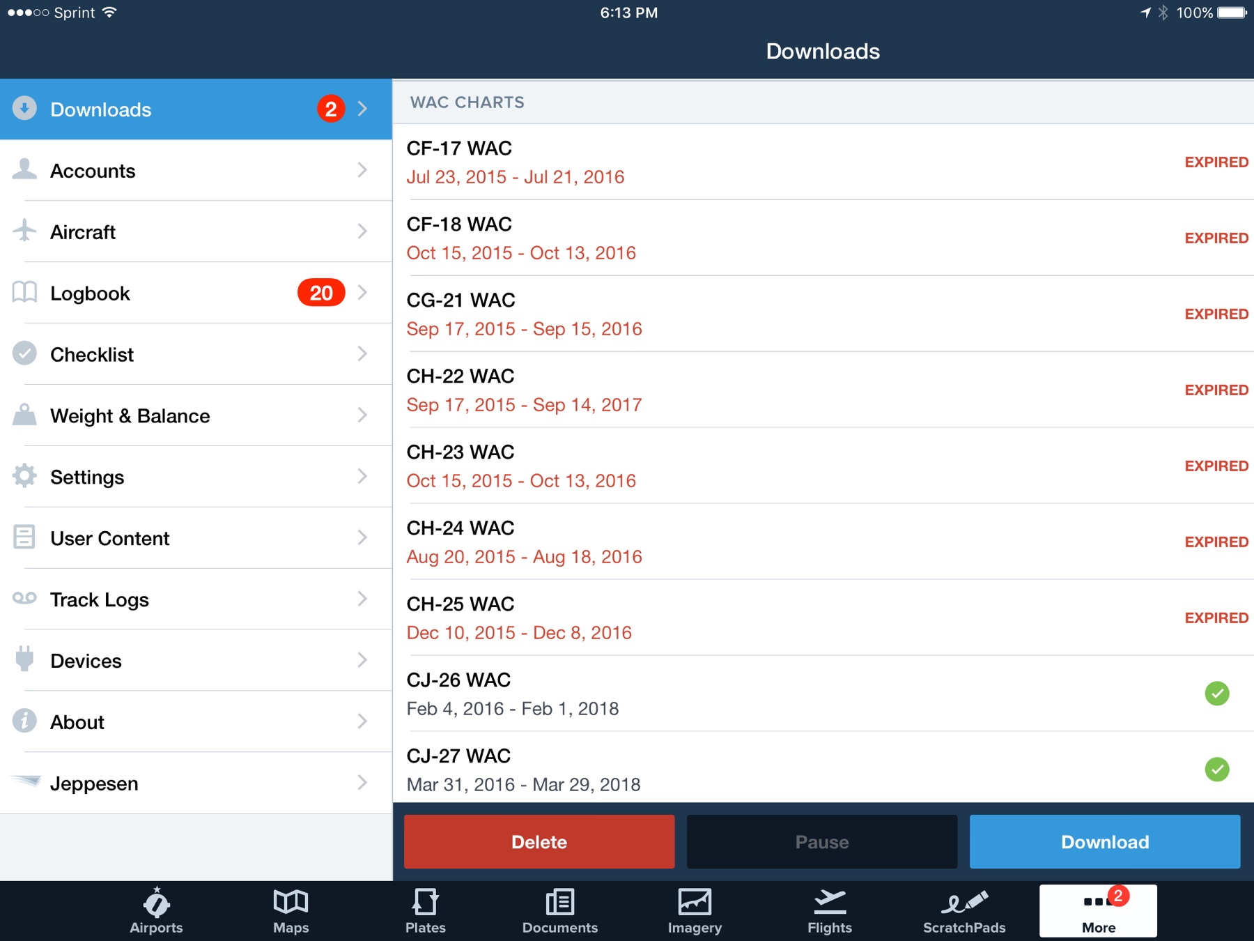
also nice to have a big ol WAC for some planning

Don't issue/sell WACs anymore. I liked using them too.

I still carry them, but then I'm a CFI. But I enjoy looking at the ground as I'm tooling around in cruise and the sectional to find things on the ground. Even carried them in the jet when I was at the airline, outdated but still carried 'em. FOs thought I was nutso. Maybe, but I still enjoy pilotage.
 
Especially for a FBO wall with the range string :)

That's a different chart than a WAC chart, and scale too. Yup think I still have one of those in a box somewhere, not as big as those old FBO ones. I also had a bunch of military "sectionals" that were even more detailed than sectionals were, bigger scale. Forget what the military called them. Still have a few around, probably in that same box.
 
Yes, I used paper sectionals a lot. Especially for wrapping gifts for pilot friends. They are a marvelous wrapping option. Heavy duty, hard to tear, easy to fold and shape etc.
I prefer to use expired sectionals for that purpose but if I can't find one, I just buy the newest release from Sporty's. :D

Used to do that for my students once they passed their ride. Bought 'em a gift and wrapped it in sectional.
 
I checked "fine with electronic" simply because the airline is all electronic.
 
I might have to get one of those as a wall decoration/quick what-if planning chart.

Back in the day FBOs would have one on the wall with a string anchored at the airport. Then they draw rings around it at say, 50, 100, 150 etc miles from the FBO/airport. You could stretch the string out to where you wanted to. Gave you an idea of heading, distance, type of airspace you'd be flying thru etc. It does come in handy.
 
I was in Key West about 6 years ago, still using paper and a buddy wanted me to drop him and his with off in Naples on the way home. He is also a pilot, he whipped out his iPad and plugged in our clearance before I read it back to the ground controller. I was hooked!! I do miss using the paper charts for a sun screen on clear days!! Between my 650/750 and iPad, I think I'm covered!

If you get an iPad Pro it can double as a sunscreen for somehing like ten Chinese slave laborers who built it. Pretty amazing device, really. Hahaha. :)

Going to get my commercial in a couple weeks at a "3 day thing". And they told me to buy paper. UGGGG!

Had that happen. AND everyone sold out of the ABQ sectional. I flew to COS to get one, I call it my $150 sectional. And then never used it during the oral or flight at all. It sat on the table with a line drawn on it, and we used iPads. LOL. Waste of freaking money and time.

Hasn't happened to me yet.

If you do any flying in the desert southwest there literally hasn't been a month without multiple GPS outage FDC NOTAMs in years. Nobody seems to actually have any trouble, but between the GPS test facility in Alamogordo and numerous military jamming tests all over out here, you're definitely flying in one of the 1000 mile (at higher altitudes) warning areas most of the time. They're all over the place.

Especially for a FBO wall with the range string :)

Loved that thing. Especially if they did it right and put the string through the hole in the city with a weight behind the chart so you could pull it out and stretch it somewhere and then it would retract into the wall on its own when you let go of it. Was fun to stand there and dream of places to fly.
 
After reading these comments, I now realize why people are afraid of water landings. ;)

I use Foreflight, Gadgets and Laminated map
 
Don't issue/sell WACs anymore. I liked using them too.

I still carry them, but then I'm a CFI. But I enjoy looking at the ground as I'm tooling around in cruise and the sectional to find things on the ground. Even carried them in the jet when I was at the airline, outdated but still carried 'em. FOs thought I was nutso. Maybe, but I still enjoy pilotage.
Me too. Especially since I moved to an area where the view from 3000 AGL is very different that what I saw for 20 years. If I am VFR I like to fly the roads, rivers, towns, quarries, lakes and powerlines to my destination, particularly if it is nearby. I even like to be able to find things on the ground on longer trips when VFR or IFR in VMC.

But I dont feel I need paper charts for that.
 
I liked using WAC Charts
Me too. Especially since I moved to an area where the view from 3000 AGL is very different that what I saw for 20 years. If I am VFR I like to fly the roads, rivers, towns, quarries, lakes and powerlines to my destination, particularly if it is nearby. I even like to be able to find things on the ground on longer trips when VFR or IFR in VMC.

But I dont feel I need paper charts for that.
I liked WACs too, especially back in paper days when they significantly reduced the need to fold and re-fold. The expired WACs are still in FF so I just went back and played with them. The suppression of certain details is still nice but I can't easily describe exactly how they are different when compared side by side with a Sectional at the same scale.

Back when I was navigating exclusively by pilotage, I liked using the Tactical charts published for the military. Same scale as Sectionals but better terrain and a bit less clutter as I recall. Urban clusters were pink rather than yellow. Civilian airports were not always accurately located however(!)

Anyway, I'm now a delighted user of FF's Aeronautical base maps. Just the right level of abstraction for travel, it can be overlaid with Sectionals or whatever when desired. My favorite combination is not fully supported however; the Aeronautical base with the street overlay. This allows me to easily locate someone's home or a pond or some other aeronautically insignificant detail relative to an airport or track. You have to play a trick to get it displayed inflight however.


Sent from my iPad using Tapatalk
 
I bought current charts as I went back into the air.
On my flight where I (still) haven't mastered ForeFlight it took me until the return flight to remember that I can get the airspace and frequencies right there all at once.
What a clever app those paper tings are!
 
Me too. Especially since I moved to an area where the view from 3000 AGL is very different that what I saw for 20 years. If I am VFR I like to fly the roads, rivers, towns, quarries, lakes and powerlines to my destination, particularly if it is nearby. I even like to be able to find things on the ground on longer trips when VFR or IFR in VMC.

But I dont feel I need paper charts for that.

So you're saying you're not missing the flat brown everywhere of late summer where the only real landmarks are lakes 100 miles apart? Haha. :)
 
You need a button that says "I use my paper maps along with my other nav aids".
I have had a subscription for the current sectional for my area and the chart supplement Alaska, and buy additional sections when needed. I have an Aera 500 but don't use the moving map as much as I use the panel page. I know the area pretty good within a 200 mile radius of my home field. I glance at the map from time to time for waypoints. I never leave home without paper charts.

I normally give passengers a sectional to play with during the flight and let them keep it after the flight if the want it.
 
So you're saying you're not missing the flat brown everywhere of late summer where the only real landmarks are lakes 100 miles apart? Haha. :)
I’m not saying that at all. I miss flying in Colorado.
 
I like the larger view of paper for the purpose of flight planning. Especially around here where there are mountains in almost every direction and I'm flying an unfamiliar route. Maybe cuz I'm a low time pilot, but I also feel more prepared if I sketch out the magenta line on paper first. I tried once planning and flying strictly by FF and mentally I felt less prepared during the flight. Also I was flying planes without a Garmin installed as well, so my backup was the paper map along with the paper flight plan.
 
I carry paper (sectional and TAC), as well as my tablet with Garmin Pilot. Two of the three planes in the club have GPS, which I use when I fly them, but the other 172 is /A. I did let my Jeppesen subscription expire this month, however. I don't fly instruments enough to justify the expense (heck, I'm not even instrument current at this time, need an IPC). But the sectional is very convenient for looking at a large area at once. Can't to that with the tablet and still read it.
 
Yeah, but what the heck is going on there now? Low, flyable IMC? In September?!!?

It was about RVR 800 at my house today all day in mist and it rained for hours yesterday. That low was 29.62 when it was west of the Rockies, so it was kinda obvious it was going to cause a big change.
 
I use paper charts nearly 100% of the time. (their batteries don't die when you forget to charge them)
But I also use the digital version with Orux, on my tablet. (just to confirm where I think I am on the paper chart)
 
But the sectional is very convenient for looking at a large area at once. Can't to that with the tablet and still read it.
That's part of the magic with FF's Aeronautical charts which have been optimized for digital display. You can't do that with a sectional.

But paper is just fine too although I would miss those WACs.


Sent from my iPad using Tapatalk
 

Yes, FF still lets users pull up the expired WACs. Interestingly, a few examples are still valid - they seem to cover the Caribbean and the last one to expire covered Mexico.
05124bf5cacc042170a22197d0957a71.png


Sent from my iPad using Tapatalk
 
Yes, FF still lets users pull up the expired WACs. Interestingly, a few examples are still valid - they seem to cover the Caribbean and the last one to expire covered Mexico.
05124bf5cacc042170a22197d0957a71.png


Sent from my iPad using Tapatalk

Can’t get them if you don’t already have them though. And one click of the Delete and then “Delete All Expired” and they’re gone.
 
I liked paper charts for sentimental reasons. Nice to have something really tangible. However, once I made the switch to ForeFlight on my iPad I never really looked back. No worries about your paper approach plates expiring and the store not having them. I also have FF on my phone as my backup. Never had overheating issues or battery problems. Most of the planes I fly have a 430, though, so I'm not running the iPad constantly.
 
I have 5 GPS based navigation systems in the plane every time I fly so I feel a paper sectional is unnecessary... so I only carry the one.
 
...................................................
....Anyway, I'm now a delighted user of FF's Aeronautical base maps. Just the right level of abstraction for travel, it can be overlaid with Sectionals or whatever when desired. My favorite combination is not fully supported however; the Aeronautical base with the street overlay. This allows me to easily locate someone's home or a pond or some other aeronautically insignificant detail relative to an airport or track. You have to play a trick to get it displayed inflight however.


Sent from my iPad using Tapatalk
I do that to. It's not that big a 'trick.' Aviation charts like Sectional and IFR are the default if you have both street and them selected. You just have to deselect the Sectional and/or IFR.
 
Back
Top