Question about VOR navigation. Lets say I have only two NAV radio CDI's in the airplane and a radio DME.
Say I want to plan a flight on a V311 from the ELT VOR to the NELLO intersection.
Flying from ELT to the first intersection, CORCE I can assure I'm on track because the VOR is only 38nm away and I can track it at least that far. After that point there is no lateral guidance because the low VOR might only go to about 40 miles. Using the HRS VOR, I can verify what radial I am on from HRS and that will tell me approximately where NELLO and AWSON are but I wouldn't be able to verify laterally exactly where I am if I drifted north or south slightly until I get to those intersections and can verify DME to HRS. I'm thinking that calculating WCA, and course should get close enough to stay within 4 miles of center without plotting distances on multiple radials of HRS along the route.
Does this make sense to plan a flight this way, or am I way off base here?
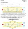