Norcal to Catalina

sacbluesman

Pre-takeoff checklist
Joined
Aug 9, 2012
Messages
108
Location
Sacramento
Display Name

Display name:
sacbluesman
Hey guys. I'm planning a flight out to Catalina in a few weeks and looking for some opinions on the route. I'll be doing this flight in a 172. I was prefering to do this flight VFR.

This is my route of flight thus far: KEDU - SAC VOR - 3O8 (fuel stop) AVE VOR - LZS VOR - VTU VOR - KAVX

This route is pretty direct. Only about 15nm more and It keeps me clear of the Lemoore MOA. One of my concerns was the inhospitable terrain N/E of Santa Barbara extending east towards the Grapevine. Would it be better to avoid that all together and fly more along the coast or should I go further East and follow I-5 or does my route look ok?

My route also keeps me clear of the LA class B however, I was wondering if its pretty common to get vectored for traffic when approaching that area.

The majority of my flying has been IFR so I'm trying to brush back up on the VFR stuff. Thanks for any input!
 
I don't have much to say about the route except that you should look at the LA TAC and consider using the SFRA (directly over LAX without having to talk to SoCal) or consider one of the other routes at higher altitudes as an option.
 
Not that I've flown this route yet, but I've looked at several options. The Hollywood Park Route looks really nice for a spam can to get to Catalina without hauling life vests around. Or just a direct overflight of Class B at 11500. Avoiding Class B to the west involves quite a lot of over-water ops, and flying through a lot of warning zones.
 
FYI: My recollection is that they don't sell fuel at AVX.
 
The terrain along your route is pretty tame--it looks worse on the map than it does out the window, and your route leaves you within power-off gliding distace of more pleasant terrain as long as you're cruising at or above 7,500.

If I was in your shoes, though, I would just overfly the Class B. Your route has a pretty long overwater segment. If you fly right over LAX and go direct over the point with the shortest overwater distance the total overwater distance is something like 26 miles (or 13 miles from shore at the most distant point), which, when flown at 10,500 or 11,500, keeps you withhin power-off gliding distance from shore at all times in the light singles I fly.
 
That's the way I used to go. On V27 to Catalina you are at most ~20 miles offshore and the waters there are chock full of boats. Carry a few preservers, and stay high until you have the field made. The terrain NE of Santa Barbara is no problem. Just do it.
 
The only complication is the fuel stop. Either the OP's planned stop or Camarillo are logical for a stop prior to continuing on to Catalina Island, which makes an LAX Class B overflight fairly unattractive. My inclination would be to just take more or less the direct route just outside of Bravo.
 
Thanks for the suggestions. I'll take another look at the chart. I'm not all that crazy of having a really long water segment so maybe one of those corridors or overflight of the bravo would be better.
 
Very cool. Let us all know how you like it! I've made it my goal to get my cert. and fly to Avalon this Summer. Have a safe and fun flight!
 
Very cool. Let us all know how you like it! I've made it my goal to get my cert. and fly to Avalon this Summer. Have a safe and fun flight!


I'll report back for sure. I was reading your other thread...any luck with a CFI yet?
 
For those that haven't been to Catalina before, there is an optical delusion to the runway. It has caused several accidents.

The runway has a significant crown to it, and there is no visible land off the west end of the runway, which is the typical departure end. On arrival, the tendency is to get too low because the land slopes up to the runway, and some pilots have hit rather hard from a low, or shallow approach.

On take off to the west, as you accelerate, from the GA plane perspective it will look like you are running out of runway due to the crown. This has forced some pilots to pull the plane off way too early while on the back side of the power curve, and then settle back onto the runway. If they are smart, they push forward, gain some speed and then take off at normal speed. If they are not smart, they mush the plane off the west end of the runway, and it does a mushing stall into the terrain to the west.

Fly by your speeds, and you'll be fine. If you notice yourself pulling it off too soon, relax back pressure and let some speed build. There's plenty of runway out there to use. Worst case scenario, there is rapidly descending terrain to the NW of the departure end. If you have to crash, just turn right about 20 deg, and keep going down. There's a beach down there, and usually some boats moored in or near it during the day. Ditch it near the water, and the swells will push you back to the beach.
 
Hey guys. I'm planning a flight out to Catalina in a few weeks and looking for some opinions on the route. I'll be doing this flight in a 172. I was prefering to do this flight VFR.

This is my route of flight thus far: KEDU - SAC VOR - 3O8 (fuel stop) AVE VOR - LZS VOR - VTU VOR - KAVX

This route is pretty direct. Only about 15nm more and It keeps me clear of the Lemoore MOA. One of my concerns was the inhospitable terrain N/E of Santa Barbara extending east towards the Grapevine. Would it be better to avoid that all together and fly more along the coast or should I go further East and follow I-5 or does my route look ok?

My route also keeps me clear of the LA class B however, I was wondering if its pretty common to get vectored for traffic when approaching that area.

The majority of my flying has been IFR so I'm trying to brush back up on the VFR stuff. Thanks for any input!

June Gloom is here and it has been pretty thick.. You may not have minimums to get in.. If you go missed climb first, then turn...

I wouldn't worry about coming over the hill to at Santa Barbara... can get a little bumpie in the afternoon other than that its pretty benign.

VTU to AVX is over a lot of water and you're in the shipping lanes. May want transition to AVX from TOA that will give you a short exposure to the water.

Once there enjoy a Buffalo Burger..
 
^^^^^

And a chocolate chip peanut butter oatmeal cookie:yes:

Also when landing, dont come in too low. Winds can push u down on final and if ur too low u will fly into the cliff. The runway is on a flat top mountain. I think off it like landing on an aircraft carrier
 
Buffalo burgers and cookies will be on the menu as long as I don't smash into the cliff or have to wait to be washed up on shore. :)

As far as the VFR corridors, how is traffic? Should I be expecting a lot of us folk going through there? The Hollywood Park Transition doesn't seem like a bad option.
 
I've done the special flight rules route half a dozen times, and I've never heard more than one other airplane using it when I was. I have gotten the impression that many locals don't like to use it, but I don't see why.
 
Buffalo burgers and cookies will be on the menu as long as I don't smash into the cliff or have to wait to be washed up on shore. :)

As far as the VFR corridors, how is traffic? Should I be expecting a lot of us folk going through there? The Hollywood Park Transition doesn't seem like a bad option.

Keep it simple... Once you cross over the VTU VOR via V299 pick up a Class B Clearance via the Costal Route... You may want to get this in the system with with SBA or Pt Magu Approach..

Getting to your question, it will depend on what day you are doing this.. I have never really seen these transitions busy and everyone is real good about announcing their position and running their lights. The Mini Route would probably be a better choice.
 
This is a difficult landing, as one poster noted above. Most rental places require a check out the first time you land there. If winds are blowing down the runway, watch out for down drafts on short final. Keep your hand on the throttle. Many pilots think they are lined up perfectly, only to apply full throttle. My instructor has witnessed two planes crash into the hill on short final due to the downdrafts.

There's a bus that goes down the hill...beautiful ride...leaves every two hours. Catalina is incredibly beautiful (I have a place there). Stay overnight if you can, and feel free to PM me with any questions about the island!
 
Oh...and also to pass LAX Class B, try the "Special VFR" route (look at your TAC)...follow the correct SMO VOR radial for an easy crossing. No clearance needed and you go right over the airport at 3,500 or 4,500. Announce yourself frequently and watch for other traffic! Also watch out for BUR Class C before you arrive at SMO.
 
SoCal coastline suffers from June Gloom as they call it, and can frequently be socked in, especially in the mornings. So plan for it, but prepared for a route that takes you closer to the I-5 and over Burbank/Van Nuys. LA airspace looks intimidating, but isn't that bad. Just be on the ball when you cross over LAX either LA Special Flight Rules or Mini Route. The LASFR is the easiest one and you don't have to talk to anyone except other aircraft and squawk.

Catalina has a kink in the rwy halfway through, which have caught many pilots off guard as they land/takeoff. Just commit - it doesn't disappear after the ridge like it looks like.
 
Last edited:
Just out of curiosity when are you planning on going?

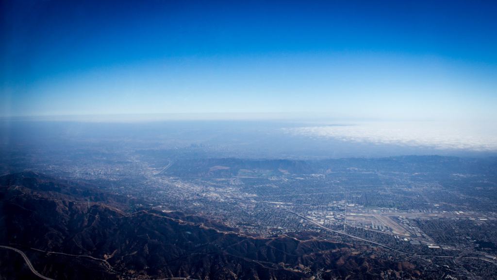
Like it was stated before the biggest problem is the fog. I was in the LA basin around a week and a half ago and I had to wait until the afternoon to get in there. and from this picture you can see that the coast was still fogged in.
yba6e9ap.jpg
 
Back
Top